|
search place name
|
||
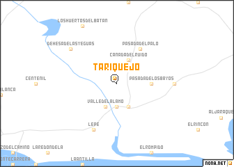
Tariquejo (Andalucía, Spain)Tariquejo is a town in the Andalucía region of Spain. An overview map of the region around Tariquejo is displayed below.
regional and 3d topo map of Tariquejo, Spain ::
Tariquejo airports ::
The nearest airport is FAO - Faro, located 78.5 km south west of Tariquejo.
Other airports nearby include SVQ - Sevilla (113.4 km east), XRY - Jerez (117.1 km south east), OZP - Sevilla Moron Ab (138.5 km east), BJZ - Badajoz Talavera La Real (177.4 km north), Nearby towns ::
La Barca (3.7km south) //
Cañada del Ruido (4.0km north) //
Valle del Álamo (4.0km south) //
Cartaya (4.0km south) //
Pasada de los Bayos (4.4km east) //
Pasada del Palo (6.3km north east) //
Lepe (8.0km south) //
Dehesa de las Yeguas (8.1km north west) //
[all distances 'as the bird flies' and approximate]  Places with similar names to Tariquejo, Spain ::
// Duricaj (AL)
// Trokaj (AL)
// Târgu Jiu (RO)
// Torkej (SD)
// Durakju (PK)
// (( Dorakaj )) (AL)
// (( Trocaj )) (AL)
// Turkeije (NL)
// Dragaj (CS)
Disclaimer :: Information on this page comes without warranty of any kind |
||
|
Where is Tariquejo? Elevation and coordinates ::
Latitude (lat): 37°19'0"N Longitude (lon): 7°10'0"W
Elevation (approx.): 39m (map arrows pan, magnifying glasses zoom) |
||
|
Visiting Tariquejo? Hotel/Accommodation ::
Book a hotel in Tariquejo Travel Guide ::
Buy a travel guide for Spain rental cars ::
car rental offers GPS waypoint ::
download a GPX waypoint (PoI) of Tariquejo for your GPS receiver
|
||