|
search place name
|
||
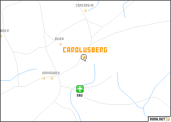
Carolusberg (South Africa)Carolusberg is a town in South Africa. An overview map of the region around Carolusberg is displayed below.
regional and 3d topo map of Carolusberg, South Africa ::
Carolusberg airports ::
The nearest airport is SBU - Springbok, located 6.3 km south of Carolusberg.
Other airports nearby include KLZ - Kleinsee (83.1 km west), AGZ - Aggeneys (92.4 km north east), ALJ - Alexander Bay (181.0 km north west), Nearby towns ::
 Places with similar names to Carolusberg, South Africa ::
// Kreilesberg (AT)
// Carlsberg (DE)
// Greilsberg (DE)
// Karlsberg (DE)
// Carlsburg (US)
// Carlsborg (US)
// Carlsbourg (BE)
// Karlsburg (DE)
// Carlsberg (DE)
// Karlsberg (SE)
Disclaimer :: Information on this page comes without warranty of any kind |
||
|
Where is Carolusberg? Elevation and coordinates ::
Latitude (lat): 29°38'0"S Longitude (lon): 17°57'0"E
Elevation (approx.): 1052m (map arrows pan, magnifying glasses zoom) |
||
|
Visiting Carolusberg? Hotel/Accommodation ::
Book a hotel in Carolusberg Travel Guide ::
rental cars ::
car rental offers GPS waypoint ::
download a GPX waypoint (PoI) of Carolusberg for your GPS receiver
|
||