|
search place name
|
||
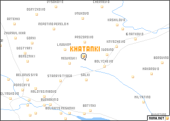
Khatanki (Moskovskaya Oblast', Russia)Khatanki is a town in the Moskovskaya Oblast' region of Russia. An overview map of the region around Khatanki is displayed below.
regional and 3d topo map of Khatanki, Russia ::
Khatanki airports ::
The nearest airport is VKO - Moscow Vnukovo, located 101.4 km east of Khatanki.
Other airports nearby include SVO - Moscow Sheremetyevo (110.8 km east), KLD - Tver Migalovo (117.3 km north), Nearby towns ::
Medvedki (2.0km west) //
Prozorovo (4.1km north) //
Sal'ki (4.3km south) //
Bolychevo (2.7km south east) //
Fedos'ino (3.0km north east) //
Lisavino (3.4km north west) //
Staraya Tyaga (5.5km south west) //
Knyazhëvo (5.0km north east) //
Repotino-Perelom (8.0km north west) //
Kashilovo (8.9km north east) //
Terekhovo (8.4km north east) //
[all distances 'as the bird flies' and approximate]  Places with similar names to Khatanki, Russia ::
// Khatanga (RU)
// Khatunka (RU)
// Khatynnakh (RU)
// Khatynnakh (RU)
// Khatynnakh (RU)
// Khotunok (RU)
// Khudanki (RU)
// Khātenga (BD)
// Khaitong (IN)
// Khatanga (IN)
Disclaimer :: Information on this page comes without warranty of any kind |
||
|
Where is Khatanki? Elevation and coordinates ::
Latitude (lat): 55°46'19"N Longitude (lon): 35°40'51"E
Elevation (approx.): 216m (map arrows pan, magnifying glasses zoom) |
||
|
Visiting Khatanki? Hotel/Accommodation ::
Book a hotel in Khatanki Travel Guide ::
Buy a travel guide for Russia rental cars ::
car rental offers GPS waypoint ::
download a GPX waypoint (PoI) of Khatanki for your GPS receiver
|
||