|
search place name
|
||
Khirlukasy (Chuvashiya, Russia)Khirlukasy is a town in the Chuvashiya region of Russia. An overview map of the region around Khirlukasy is displayed below.
regional and 3d topo map of Khirlukasy, Russia ::

Nearby towns ::
Osinovo (0.9km south) //
Shumshevashi (1.8km south east) //
Kark-Sirmy (2.1km north east) //
Bol'shiye Atmeni (1.9km south east) //
Yamashi (2.7km south west) //
Baymashkino (3.7km south) //
Shuka-Kasy (2.2km east) //
Malyye Atmeni (2.8km south east) //
Kalugino (4.5km south) //
Akchikasy (4.3km south west) //
Cherepanovo (5.2km south) //
Mochey (4.6km north east) //
Ispukhany (4.3km north east) //
Mizherkasy (3.8km west) //
Yangil'dino (6.4km south) //
Krasnyye Chetai (7.1km south) //
Il'ina Gora (7.8km north) //
Alikovo (4.5km east) //
Tomley (6.0km south east) //
Torkhany (5.0km east) //
Sholya (5.6km south west) //
Izhekey (6.2km south east) //
Piterkino (8.8km south) //
Taloy (8.2km north east) //
[all distances 'as the bird flies' and approximate] 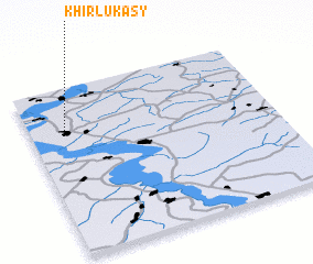 Places with similar names to Khirlukasy, Russia :: Disclaimer :: Information on this page comes without warranty of any kind |
||
|
Where is Khirlukasy? Elevation and coordinates ::
Latitude (lat): 55°45'10"N Longitude (lon): 46°8'54"E
Elevation (approx.): 129m (map arrows pan, magnifying glasses zoom) |
||
|
Visiting Khirlukasy? Hotel/Accommodation ::
Book a hotel in Khirlukasy Travel Guide ::
Buy a travel guide for Russia rental cars ::
car rental offers GPS waypoint ::
download a GPX waypoint (PoI) of Khirlukasy for your GPS receiver
|
||