|
search place name
|
||
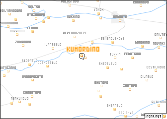
Kumordino (Tverskaya Oblast', Russia)Kumordino is a town in the Tverskaya Oblast' region of Russia. An overview map of the region around Kumordino is displayed below.
regional and 3d topo map of Kumordino, Russia ::
Kumordino airports ::
The nearest airport is KLD - Tver Migalovo, located 22.2 km east of Kumordino.
Other airports nearby include VKO - Moscow Vnukovo (181.5 km south east), Nearby towns ::
Golykhino (0.4km north east) //
Tutan' (2.4km north) //
Volyntsevo (4.0km north) //
Perekhozheye (5.2km north) //
Shepelëvo (3.5km south east) //
Tukhin' (3.9km east) //
Ivantsëvo (4.5km north west) //
Shutovo (6.5km south) //
Semënovskoye (5.2km north east) //
Zaborov'ye (7.4km south) //
Rozhdestvo (4.7km west) //
Mikheyevo (5.2km south east) //
Mukhino (8.8km north) //
Berglezovo (8.7km south) //
Mednoye (9.8km north east) //
[all distances 'as the bird flies' and approximate]  Places with similar names to Kumordino, Russia ::
// Kamardan (RU)
// Kamardina (RU)
// Komardina (RU)
// Camroden (US)
// Kimberton (US)
// Comertown (US)
// Kambaridéni (BF)
// Qamar ed Dîne (LB)
// Kamar Dehnow (IR)
// Kamar Dūnī (IR)
Disclaimer :: Information on this page comes without warranty of any kind |
||
|
Where is Kumordino? Elevation and coordinates ::
Latitude (lat): 56°50'50"N Longitude (lon): 35°23'45"E
Elevation (approx.): 148m (map arrows pan, magnifying glasses zoom) |
||
|
Visiting Kumordino? Hotel/Accommodation ::
Book a hotel in Kumordino Travel Guide ::
Buy a travel guide for Russia rental cars ::
car rental offers GPS waypoint ::
download a GPX waypoint (PoI) of Kumordino for your GPS receiver
|
||