|
search place name
|
||
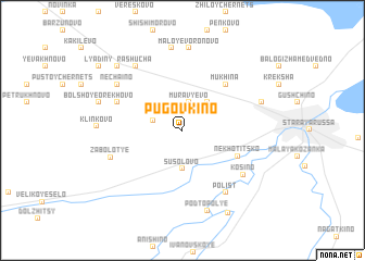
Pugovkino (Novgorodskaya Oblast', Russia)Pugovkino is a town in the Novgorodskaya Oblast' region of Russia. An overview map of the region around Pugovkino is displayed below.
regional and 3d topo map of Pugovkino, Russia ::
Pugovkino airports ::
The nearest airport is LED - St. Petersburg Pulkovo, located 209.3 km north of Pugovkino.
Nearby towns ::
Murav'yëvo (2.9km north) //
Vyselok Paseki (1.9km north west) //
Vesëlaya Gorka (3.2km north east) //
Susolovo (4.0km south) //
Nekhotitsko (4.0km south east) //
Mukhina (5.3km north east) //
Maloye Orekhovo (4.6km north west) //
Kosino (5.6km south east) //
Polist' (6.8km south) //
Zabolot'ye (4.8km south west) //
Rashucha (7.1km north) //
Nechaino (5.9km north west) //
Maloye Voronovo (8.4km north) //
Lukino (8.5km north) //
Dubovitsy (5.2km north east) //
Podtopol'ye (8.4km south) //
Klinkovo (4.7km west) //
Bol'shoye Orekhovo (5.4km north west) //
Nagovo (7.5km north west) //
Utushkino (8.9km south) //
Lyadiny (8.0km north west) //
[all distances 'as the bird flies' and approximate]  Places with similar names to Pugovkino, Russia ::
// Pougouvagné (CI)
Disclaimer :: Information on this page comes without warranty of any kind |
||
|
Where is Pugovkino? Elevation and coordinates ::
Latitude (lat): 57°59'27"N Longitude (lon): 31°14'37"E
Elevation (approx.): 28m (map arrows pan, magnifying glasses zoom) |
||
|
Visiting Pugovkino? Hotel/Accommodation ::
Book a hotel in Pugovkino Travel Guide ::
Buy a travel guide for Russia rental cars ::
car rental offers GPS waypoint ::
download a GPX waypoint (PoI) of Pugovkino for your GPS receiver
|
||