|
search place name
|
||
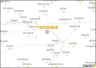
Tenyakovo (Moskovskaya Oblast', Russia)Tenyakovo is a town in the Moskovskaya Oblast' region of Russia. An overview map of the region around Tenyakovo is displayed below.
regional and 3d topo map of Tenyakovo, Russia ::
Tenyakovo airports ::
The nearest airport is VKO - Moscow Vnukovo, located 70.5 km north west of Tenyakovo.
Other airports nearby include SVO - Moscow Sheremetyevo (107.2 km north), Nearby towns ::
Semënovskoye (2.8km north west) //
Prudno (4.2km south east) //
Myshenskoye (3.0km south west) //
Avdot'yevo (3.5km north west) //
Zalugi (5.6km south) //
Khatun' (4.8km south east) //
Dubecheno (5.7km north west) //
Sumorokovo (7.4km north) //
Pochinki (7.5km south) //
Kolychëvo (4.4km west) //
Anan'ino (7.2km north) //
Chirkovo (8.0km north) //
Ivanovskoye (6.1km north east) //
Shëlkovo (5.9km north west) //
Lapino (8.8km south) //
Ol'gino (9.5km north) //
Tolbino (9.3km south east) //
[all distances 'as the bird flies' and approximate] 
Disclaimer :: Information on this page comes without warranty of any kind |
||
|
Where is Tenyakovo? Elevation and coordinates ::
Latitude (lat): 55°2'1"N Longitude (lon): 37°47'18"E
Elevation (approx.): 159m (map arrows pan, magnifying glasses zoom) |
||
|
Visiting Tenyakovo? Hotel/Accommodation ::
Book a hotel in Tenyakovo Travel Guide ::
Buy a travel guide for Russia rental cars ::
car rental offers GPS waypoint ::
download a GPX waypoint (PoI) of Tenyakovo for your GPS receiver
|
||