|
search place name
|
||
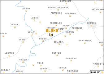
Blake (Alabama, United States - USA)Blake is a town in the Alabama region of United States - USA. An overview map of the region around Blake is displayed below.
regional and 3d topo map of Blake, United States - USA ::
Blake airports ::
The nearest airport is ANB - Anniston Metro, located 62.2 km north west of Blake.
Other airports nearby include LSF - Fort Benning Lawson Aaf (98.5 km south east), MXF - Montgomery Maxwell Afb (114.6 km south west), ATL - Hartsfield Jackson Atlanta Intl (115.4 km north east), BHM - Birmingham Intl (126.8 km north west), Nearby towns ::
Concord (2.4km north) //
Abanda (3.1km south west) //
Dickert (3.3km north east) //
Red Level (3.4km south east) //
Mount Olive (4.3km north) //
Pooles Crossroad (3.9km east) //
Louina (4.9km west) //
Peavy (5.4km north east) //
Clackville (5.4km south east) //
High Pine (5.5km east) //
Forester Chapel (6.3km north west) //
Milltown (6.8km south) //
Wadley (6.2km west) //
Friendship (7.9km north) //
Corinth (8.0km north west) //
Broughton (9.4km north east) //
Rock Fence (10.4km south east) //
[all distances 'as the bird flies' and approximate] 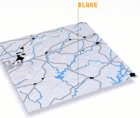 Places with similar names to Blake, United States - USA ::
Disclaimer :: Information on this page comes without warranty of any kind |
||
|
Where is Blake? Elevation and coordinates ::
Latitude (lat): 33°6'50"N Longitude (lon): 85°30'3"W
Elevation (approx.): 202m (map arrows pan, magnifying glasses zoom) |
||
|
Visiting Blake? Hotel/Accommodation ::
Book a hotel in Blake Travel Guide ::
rental cars ::
car rental offers GPS waypoint ::
download a GPX waypoint (PoI) of Blake for your GPS receiver
|
||