|
search place name
|
||
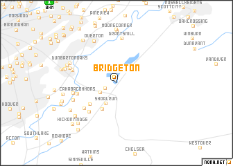
Bridgeton (Alabama, United States - USA)Bridgeton is a town in the Alabama region of United States - USA. An overview map of the region around Bridgeton is displayed below.
regional and 3d topo map of Bridgeton, United States - USA ::
Bridgeton airports ::
The nearest airport is BHM - Birmingham Intl, located 15.9 km north west of Bridgeton.
Other airports nearby include ANB - Anniston Metro (76.0 km east), MXF - Montgomery Maxwell Afb (120.8 km south), HUA - Redstone Aaf (137.0 km north), CBM - Colombus Columbus Afb (167.4 km west), Nearby towns ::
Brook Highland (1.8km south west) //
Lake Purdy (2.6km south west) //
Shoal Run (3.7km south west) //
Little Ridge Estates (4.7km south west) //
Morning Sun Villas (4.9km south west) //
Meadowbrook (5.9km south west) //
Inverness Cliffs (5.9km south west) //
Cahaba Commons (5.6km west) //
Cahaba Cliffs (6.0km west) //
Grants Mill (7.1km north) //
Cahaba Oaks (6.2km west) //
Inverness Point (6.5km south west) //
Overton (7.4km north west) //
Overton Manor (6.6km west) //
Dunbarton Oaks (7.0km north west) //
Moore Corner (8.4km north) //
Wellington Park (7.2km north west) //
Meadow Ridge (7.6km south west) //
Shady Acres Trailer Park (8.6km north) //
Cahaba Heights (7.3km west) //
Woodford (7.6km south west) //
Nottingham (8.2km north west) //
Acton (7.5km west) //
Sunnymeadows (8.4km south west) //
Asbury Park (7.7km west) //
Camp Horne (7.8km west) //
Heritage Oaks (9.1km south west) //
Hickory Ridge (8.9km south west) //
Holiday Gardens (10.0km north west) //
[all distances 'as the bird flies' and approximate]  Places with similar names to Bridgeton, United States - USA ::
// Bargytown (US)
// Bridgetown (US)
// Bridgeton (US)
// Brejdyny (PL)
// Bridgetown (ZA)
// Bridgetown (US)
// Bridgeton (US)
// Bridgeton (US)
// Bridgeton (US)
// Bridgeton (US)
Disclaimer :: Information on this page comes without warranty of any kind |
||
|
Where is Bridgeton? Elevation and coordinates ::
Latitude (lat): 33°26'38"N Longitude (lon): 86°39'27"W
Elevation (approx.): 187m (map arrows pan, magnifying glasses zoom) |
||
|
Visiting Bridgeton? Hotel/Accommodation ::
Book a hotel in Bridgeton Travel Guide ::
rental cars ::
car rental offers GPS waypoint ::
download a GPX waypoint (PoI) of Bridgeton for your GPS receiver
|
||