|
search place name
|
||
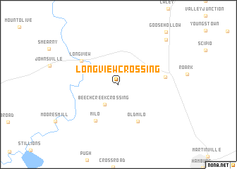
Longview Crossing (Arkansas, United States - USA)Longview Crossing is a town in the Arkansas region of United States - USA. An overview map of the region around Longview Crossing is displayed below.
regional and 3d topo map of Longview Crossing, United States - USA ::
Longview Crossing airports ::
The nearest airport is ELD - El Dorado South Arkansas Rgnl At Goodwin Fld, located 84.6 km west of Longview Crossing.
Other airports nearby include MLU - Monroe Rgnl (93.4 km south), LIT - Little Rock Adams Fld (155.9 km north), GWO - Greenwood Leflore (171.2 km east), LRF - Jacksonville Little Rock Afb (175.5 km north), Nearby towns ::
Beech Creek Crossing (3.7km south west) //
Old Milo (6.3km south east) //
Milo (6.5km south west) //
Longview (6.2km north west) //
Fountain Hill (6.4km east) //
Carpenter (9.5km north east) //
Goose Hollow (10.4km north east) //
[all distances 'as the bird flies' and approximate] 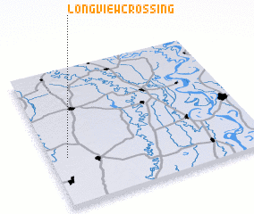 Places with similar names to Longview Crossing, United States - USA :: Disclaimer :: Information on this page comes without warranty of any kind |
||
|
Where is Longview Crossing? Elevation and coordinates ::
Latitude (lat): 33°20'49"N Longitude (lon): 91°55'3"W
Elevation (approx.): 42m (map arrows pan, magnifying glasses zoom) |
||
|
Visiting Longview Crossing? Hotel/Accommodation ::
Book a hotel in Longview Crossing Travel Guide ::
rental cars ::
car rental offers GPS waypoint ::
download a GPX waypoint (PoI) of Longview Crossing for your GPS receiver
|
||