|
search place name
|
||
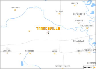
Tarnceville (Arkansas, United States - USA)Tarnceville is a town in the Arkansas region of United States - USA. An overview map of the region around Tarnceville is displayed below.
regional and 3d topo map of Tarnceville, United States - USA ::
Tarnceville airports ::
The nearest airport is LRF - Jacksonville Little Rock Afb, located 50.5 km west of Tarnceville.
Other airports nearby include LIT - Little Rock Adams Fld (58.3 km west), JBR - Jonesboro Muni (139.6 km north east), MEM - Memphis Intl (150.2 km east), NQA - Millington Rgnl Jetport (167.8 km east), Nearby towns ::
Barrettsville (6.2km west) //
Hazen (7.7km south) //
Childers (8.9km north east) //
Screeton (9.4km south west) //
[all distances 'as the bird flies' and approximate]  Places with similar names to Tarnceville, United States - USA ::
// Transvaal (BO)
// Transvaal (DE)
// Transval (DE)
// Darreh Ney-ye Soflá (IR)
// Dranesville (US)
// Transvaal (CO)
// Transvaal (GT)
// Transval (MX)
// Terrenceville (CA)
// Torrens Vale (AU)
Disclaimer :: Information on this page comes without warranty of any kind |
||
|
Where is Tarnceville? Elevation and coordinates ::
Latitude (lat): 34°50'51"N Longitude (lon): 91°36'12"W
Elevation (approx.): 67m (map arrows pan, magnifying glasses zoom) |
||
|
Visiting Tarnceville? Hotel/Accommodation ::
Book a hotel in Tarnceville Travel Guide ::
rental cars ::
car rental offers GPS waypoint ::
download a GPX waypoint (PoI) of Tarnceville for your GPS receiver
|
||