|
search place name
|
||
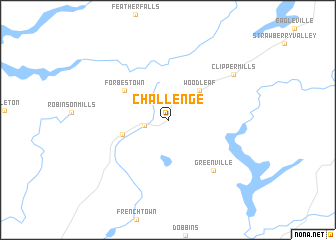
Challenge (California, United States - USA)Challenge is a town in the California region of United States - USA. An overview map of the region around Challenge is displayed below.
regional and 3d topo map of Challenge, United States - USA ::
Challenge airports ::
The nearest airport is BAB - Marysville Beale Afb, located 43.2 km south west of Challenge.
Other airports nearby include MCC - Sacramento Mc Clellan Afld (92.3 km south), SMF - Sacramento Intl (93.5 km south), SAC - Sacramento Executive (110.8 km south), RIU - Rancho Murieta (111.6 km south), Nearby towns ::
Sharon Valley (2.1km west) //
Woodleaf (4.3km north east) //
Brownsville (4.2km west) //
Forbestown (5.0km north west) //
Greenville (6.9km south east) //
Clipper Mills (7.6km north east) //
[all distances 'as the bird flies' and approximate]  Places with similar names to Challenge, United States - USA ::
// Shulenj (AL)
// Challenge (US)
// Chālunja (BD)
// Chilenje (ZM)
// Chillanjay (PE)
// Chullunjia (PE)
// Cholonge (FR)
// Shilanji (CN)
// Chalonge (FR)
// Chilingi (MW)
Disclaimer :: Information on this page comes without warranty of any kind |
||
|
Where is Challenge? Elevation and coordinates ::
Latitude (lat): 39°29'15"N Longitude (lon): 121°13'21"W
Elevation (approx.): 799m (map arrows pan, magnifying glasses zoom) |
||
|
Visiting Challenge? Hotel/Accommodation ::
Book a hotel in Challenge Travel Guide ::
rental cars ::
car rental offers GPS waypoint ::
download a GPX waypoint (PoI) of Challenge for your GPS receiver
|
||