|
search place name
|
||
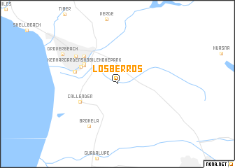
Los Berros (California, United States - USA)Los Berros is a town in the California region of United States - USA. An overview map of the region around Los Berros is displayed below.
regional and 3d topo map of Los Berros, United States - USA ::
Los Berros airports ::
The nearest airport is VBG - Lompoc Vandenberg Afb, located 38.1 km south of Los Berros.
Other airports nearby include BFL - Bakersfield Meadows Fld (140.7 km east), NTD - Point Mugu Nas (168.2 km south east), FAT - Fresno Yosemite Intl (202.5 km north), Nearby towns ::
Ken Mar Gardens Mobile Home Park (5.2km north west) //
Grande Mobile Manor Mobile Home Park (5.3km north west) //
Halcyon (5.5km north west) //
Callender (5.7km south west) //
Arroyo Grande (6.2km north west) //
Cuna Vista Mobile Home Park (5.8km west) //
Cienega Seabreeze Mobile Home Park (6.0km west) //
Fairoaks (7.0km north west) //
Bromela (7.8km south west) //
Grover Beach (8.6km north west) //
[all distances 'as the bird flies' and approximate]  Places with similar names to Los Berros, United States - USA ::
// Los Burros (US)
// Los Barrios (PA)
// Włościbórz (PL)
// Włościborz (PL)
// Los Barrios (CU)
// Los Berros (CU)
// Los Barrios (ES)
// Los Barrios (ES)
// Los Barros (ES)
// Las Breas (CL)
Disclaimer :: Information on this page comes without warranty of any kind |
||
|
Where is Los Berros? Elevation and coordinates ::
Latitude (lat): 35°4'44"N Longitude (lon): 120°32'30"W
Elevation (approx.): 67m (map arrows pan, magnifying glasses zoom) |
||
|
Visiting Los Berros? Hotel/Accommodation ::
Book a hotel in Los Berros Travel Guide ::
rental cars ::
car rental offers GPS waypoint ::
download a GPX waypoint (PoI) of Los Berros for your GPS receiver
|
||