|
search place name
|
||
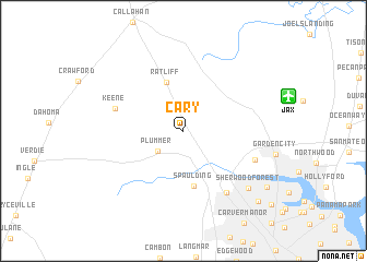
Cary (Florida, United States - USA)Cary is a town in the Florida region of United States - USA. An overview map of the region around Cary is displayed below.
regional and 3d topo map of Cary, United States - USA ::
Cary airports ::
The nearest airport is JAX - Jacksonville Intl, located 9.9 km east of Cary.
Other airports nearby include NIP - Jacksonville Nas (27.0 km south), GNV - Gainesville Rgnl (97.7 km south west), VAD - Valdosta Moody Afb (146.1 km north west), SVN - Hunter Aaf (182.0 km north), Nearby towns ::
Plummer (3.1km south west) //
Ratliff (5.2km north) //
Spaulding (5.7km south) //
Keene (6.4km west) //
Dinsmore (7.4km south east) //
Biscayne Village (6.9km south east) //
Sherwood Forest (8.2km south east) //
Beverly Hills (9.3km south east) //
Harbor View (9.7km south east) //
[all distances 'as the bird flies' and approximate] 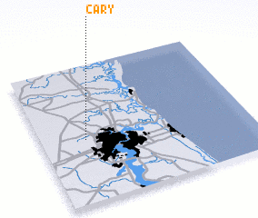 Places with similar names to Cary, United States - USA ::
Disclaimer :: Information on this page comes without warranty of any kind |
||
|
Where is Cary? Elevation and coordinates ::
Latitude (lat): 30°27'45"N Longitude (lon): 81°47'4"W
Elevation (approx.): 7m (map arrows pan, magnifying glasses zoom) |
||
|
Visiting Cary? Hotel/Accommodation ::
Book a hotel in Cary Travel Guide ::
rental cars ::
car rental offers GPS waypoint ::
download a GPX waypoint (PoI) of Cary for your GPS receiver
|
||