|
search place name
|
||
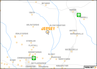
Jersey (Georgia, United States - USA)Jersey is a town in the Georgia region of United States - USA. An overview map of the region around Jersey is displayed below.
regional and 3d topo map of Jersey, United States - USA ::
Jersey airports ::
The nearest airport is ATL - Hartsfield Jackson Atlanta Intl, located 59.0 km west of Jersey.
Other airports nearby include MGE - Marietta Dobbins Arb (Atlanta Nas) (70.0 km west), MCN - Macon Middle Georgia Rgnl (114.3 km south), WRB - Macon Robins Afb (120.8 km south), AND - Andersen Anderson Rgnl (132.6 km north east), Nearby towns ::
Alcovy Mountain (4.1km north east) //
Walnut Grove (5.8km north west) //
Stone Lea (6.5km south west) //
Flint Hill (7.0km south west) //
Alcovy (8.5km south) //
Greenwood Acres (8.0km south west) //
Airport Grove (8.7km south west) //
Pine Top Hill (9.6km south) //
Youth (9.4km north west) //
Meadow View (9.5km south west) //
Dialtown (9.7km south west) //
Essex Village (10.0km south west) //
Murphy Hills (10.2km south west) //
[all distances 'as the bird flies' and approximate]  Places with similar names to Jersey, United States - USA ::
Disclaimer :: Information on this page comes without warranty of any kind |
||
|
Where is Jersey? Elevation and coordinates ::
Latitude (lat): 33°42'56"N Longitude (lon): 83°47'56"W
Elevation (approx.): 259m (map arrows pan, magnifying glasses zoom) |
||
|
Visiting Jersey? Hotel/Accommodation ::
Book a hotel in Jersey Travel Guide ::
rental cars ::
car rental offers GPS waypoint ::
download a GPX waypoint (PoI) of Jersey for your GPS receiver
|
||