|
search place name
|
||
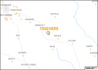
Truckers (Georgia, United States - USA)Truckers is a town in the Georgia region of United States - USA. An overview map of the region around Truckers is displayed below.
regional and 3d topo map of Truckers, United States - USA ::
Truckers airports ::
The nearest airport is SAV - Savannah Hilton Head Intl, located 47.9 km south east of Truckers.
Other airports nearby include SVN - Hunter Aaf (59.9 km south east), NBC - Beaufort Mcas (86.8 km east), AGS - Bush Field Augusta Rgnl At Bush Fld (116.7 km north), CHS - Charleston Afb Intl (161.2 km east), Nearby towns ::
 Places with similar names to Truckers, United States - USA ::
// Dar Kraïz (MA)
// Torregrosa (ES)
// Trigueros (ES)
// Darreh Korsī (IR)
// Deer Cross (US)
// Turrúcares (CR)
// Trigueras (MX)
// Terre Grasse (HT)
// Trou Gras (HT)
// Trégourez (FR)
Disclaimer :: Information on this page comes without warranty of any kind |
||
|
Where is Truckers? Elevation and coordinates ::
Latitude (lat): 32°21'20"N Longitude (lon): 81°38'3"W
Elevation (approx.): 38m (map arrows pan, magnifying glasses zoom) |
||
|
Visiting Truckers? Hotel/Accommodation ::
Book a hotel in Truckers Travel Guide ::
rental cars ::
car rental offers GPS waypoint ::
download a GPX waypoint (PoI) of Truckers for your GPS receiver
|
||