|
search place name
|
||
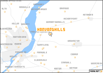
Harvard Hills (Illinois, United States - USA)Harvard Hills is a town in the Illinois region of United States - USA. An overview map of the region around Harvard Hills is displayed below.
regional and 3d topo map of Harvard Hills, United States - USA ::
Harvard Hills airports ::
The nearest airport is IKK - Greater Kankakee, located 142.9 km east of Harvard Hills.
Other airports nearby include MDW - Chicago Midway Intl (186.5 km north east), ORD - Chicago Ohare Intl (191.5 km north east), STL - St. Louis Lambert St Louis Intl (232.6 km south), Nearby towns ::
Beverly Manor (3.9km south) //
Trailpark Gardens (3.2km west) //
Germantown Hills (4.4km north) //
Sunnyland (4.7km south west) //
Robein (5.1km south west) //
Farmdale (7.4km south) //
Fondulac Plaza Shopping Center (7.6km south west) //
Washington (6.8km south east) //
Hickory Point (7.6km north east) //
Long Shore Park (7.4km north west) //
Highway Village (8.8km south west) //
Cooper (10.0km south east) //
[all distances 'as the bird flies' and approximate]  Places with similar names to Harvard Hills, United States - USA ::
// Harford Hills (US)
// Harford Hills (US)
Disclaimer :: Information on this page comes without warranty of any kind |
||
|
Where is Harvard Hills? Elevation and coordinates ::
Latitude (lat): 40°43'43"N Longitude (lon): 89°28'53"W
Elevation (approx.): 236m (map arrows pan, magnifying glasses zoom) |
||
|
Visiting Harvard Hills? Hotel/Accommodation ::
Book a hotel in Harvard Hills Travel Guide ::
rental cars ::
car rental offers GPS waypoint ::
download a GPX waypoint (PoI) of Harvard Hills for your GPS receiver
|
||