|
search place name
|
||
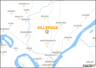
Villa Ridge (Illinois, United States - USA)Villa Ridge is a town in the Illinois region of United States - USA. An overview map of the region around Villa Ridge is displayed below.
regional and 3d topo map of Villa Ridge, United States - USA ::
Villa Ridge airports ::
The nearest airport is BYH - Blytheville Arkansas Intl, located 148.5 km south west of Villa Ridge.
Other airports nearby include HOP - Hopkinsville Campbell Aaf (160.8 km east), BLV - Belleville Scott Afb Midamerica (163.9 km north), MKL - Jackson Mc Kellar Sipes Rgnl (174.8 km south), JBR - Jonesboro Muni (196.5 km south west), Nearby towns ::
Spencer Heights (3.5km south) //
North Mounds (4.0km south) //
Mounds (4.9km south) //
Pryortown (5.4km north east) //
Pulaski (6.2km north) //
America (6.7km east) //
Hodges Park (6.8km west) //
Unity (7.0km west) //
Mound City (8.6km south) //
Cache (8.8km south west) //
Sandusky (8.4km north west) //
Tamms (10.8km north west) //
[all distances 'as the bird flies' and approximate]  Places with similar names to Villa Ridge, United States - USA ::
// Villarejo (ES)
// Villarejo (ES)
// Villarejo (ES)
// Villarejo (ES)
// Villarijo (ES)
// Valley Ridge (US)
// Villa Ridge (US)
// Villa Ridge (US)
// Valley Ridge (US)
// Villa Roja (CO)
Disclaimer :: Information on this page comes without warranty of any kind |
||
|
Where is Villa Ridge? Elevation and coordinates ::
Latitude (lat): 37°9'31"N Longitude (lon): 89°11'41"W
Elevation (approx.): 125m (map arrows pan, magnifying glasses zoom) |
||
|
Visiting Villa Ridge? Hotel/Accommodation ::
Book a hotel in Villa Ridge Travel Guide ::
rental cars ::
car rental offers GPS waypoint ::
download a GPX waypoint (PoI) of Villa Ridge for your GPS receiver
|
||