|
search place name
|
||
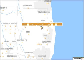
Winthrop Harbor Station (Illinois, United States - USA)Winthrop Harbor Station is a town in the Illinois region of United States - USA. An overview map of the region around Winthrop Harbor Station is displayed below.
regional and 3d topo map of Winthrop Harbor Station, United States - USA ::
Winthrop Harbor Station airports ::
The nearest airport is MKE - Milwaukee General Mitchell Intl, located 52.2 km north of Winthrop Harbor Station.
Other airports nearby include ORD - Chicago Ohare Intl (55.8 km south), MDW - Chicago Midway Intl (77.3 km south), MSN - Madison Dane Co Rgnl Truax Fld (142.5 km north west), IKK - Greater Kankakee (156.3 km south), Nearby towns ::
Winthrop Harbor (1.8km east) //
State Line (2.6km north east) //
Tobin (3.2km north) //
Camp Logan (2.8km south east) //
Zion (3.8km south) //
Carol Beach (4.7km north east) //
Eddy (4.8km south west) //
Beach Station (6.4km south) //
Beach Park (6.4km south) //
Bancroft Corners (6.6km south) //
Dunes Park (6.7km south) //
South Kenosha (6.9km north) //
Russell (5.7km west) //
Wadsworth (8.6km south west) //
[all distances 'as the bird flies' and approximate]  Places with similar names to Winthrop Harbor Station, United States - USA :: Disclaimer :: Information on this page comes without warranty of any kind |
||
|
Where is Winthrop Harbor Station? Elevation and coordinates ::
Latitude (lat): 42°28'44"N Longitude (lon): 87°50'42"W
Elevation (approx.): 208m (map arrows pan, magnifying glasses zoom) |
||
|
Visiting Winthrop Harbor Station? Hotel/Accommodation ::
Book a hotel in Winthrop Harbor Station Travel Guide ::
rental cars ::
car rental offers GPS waypoint ::
download a GPX waypoint (PoI) of Winthrop Harbor Station for your GPS receiver
|
||