|
search place name
|
||
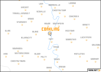
Conkling (Kentucky, United States - USA)Conkling is a town in the Kentucky region of United States - USA. An overview map of the region around Conkling is displayed below.
regional and 3d topo map of Conkling, United States - USA ::
Conkling airports ::
The nearest airport is TYS - Knoxville Mc Ghee Tyson, located 176.4 km south of Conkling.
Other airports nearby include LOU - Louisville Bowman Fld (197.6 km north west), LUK - Cincinnati Muni Lunken Fld (201.5 km north), CVG - Cincinnati Northern Kentucky Intl (203.9 km north west), Nearby towns ::
Taft (2.2km south) //
Major (3.7km north) //
Southfork (4.4km north east) //
Blake (4.4km west) //
Trixie (5.4km south) //
Ricetown (6.0km east) //
Sebastian (6.6km east) //
Scoville (8.5km north) //
Island City (7.1km west) //
Alger (8.4km south west) //
Endee (7.8km north west) //
Felty (8.9km south) //
Eversole (8.5km north east) //
Chestnut Gap (9.0km north) //
Cowcreek (9.5km north east) //
[all distances 'as the bird flies' and approximate]  Places with similar names to Conkling, United States - USA ::
// Cancalanug (PH)
// Cangalong (PH)
// Cankilang (PH)
// KuNkolonga (ZA)
// Gongolong (TD)
// Kangalanga (CD)
// Kangulungu (CD)
// Kangulungu (CD)
// Kangulungu (CD)
// Kangulungu (CD)
Disclaimer :: Information on this page comes without warranty of any kind |
||
|
Where is Conkling? Elevation and coordinates ::
Latitude (lat): 37°22'53"N Longitude (lon): 83°41'24"W
Elevation (approx.): 269m (map arrows pan, magnifying glasses zoom) |
||
|
Visiting Conkling? Hotel/Accommodation ::
Book a hotel in Conkling Travel Guide ::
rental cars ::
car rental offers GPS waypoint ::
download a GPX waypoint (PoI) of Conkling for your GPS receiver
|
||