|
search place name
|
||
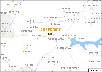
Rose Point (Pennsylvania, United States - USA)Rose Point is a town in the Pennsylvania region of United States - USA. An overview map of the region around Rose Point is displayed below.
regional and 3d topo map of Rose Point, United States - USA ::
Rose Point airports ::
The nearest airport is YNG - Youngstown Warren Rgnl, located 52.5 km north west of Rose Point.
Other airports nearby include PIT - Pittsburgh (pennsylva) Pittsburgh Intl (53.3 km south), AKR - Akron Fulton Intl (108.0 km west), CLE - Cleveland Hopkins Intl (147.9 km west), AOO - Altoona Blair Co (174.7 km south east), Nearby towns ::
Kennedy Mill (2.5km north) //
Grant City (2.4km north east) //
McConnells Mill (2.4km south east) //
Rockville (3.8km north) //
Princeton (3.8km west) //
Harlansburg (6.0km north) //
Shawwood Park (5.0km east) //
Portersville (6.4km south east) //
Gibsondale (5.8km north west) //
Elliotts Mills (8.1km north east) //
McCaslin (7.6km north west) //
Jacksville (8.1km north east) //
Energy (8.0km south west) //
Moores Corners (10.1km north east) //
[all distances 'as the bird flies' and approximate]  Places with similar names to Rose Point, United States - USA ::
// Racepond (US)
// Rosspoint (US)
// Rays Point (US)
// Rose Point (US)
// Rose Point (US)
// Rispond (GB)
Disclaimer :: Information on this page comes without warranty of any kind |
||
|
Where is Rose Point? Elevation and coordinates ::
Latitude (lat): 40°58'12"N Longitude (lon): 80°11'12"W
Elevation (approx.): 340m (map arrows pan, magnifying glasses zoom) |
||
|
Visiting Rose Point? Hotel/Accommodation ::
Book a hotel in Rose Point Travel Guide ::
rental cars ::
car rental offers GPS waypoint ::
download a GPX waypoint (PoI) of Rose Point for your GPS receiver
|
||