|
search place name
|
||
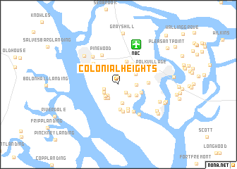
Colonial Heights (South Carolina, United States - USA)Colonial Heights is a town in the South Carolina region of United States - USA. An overview map of the region around Colonial Heights is displayed below.
regional and 3d topo map of Colonial Heights, United States - USA ::
Colonial Heights airports ::
The nearest airport is NBC - Beaufort Mcas, located 6.7 km north of Colonial Heights.
Other airports nearby include SAV - Savannah Hilton Head Intl (53.7 km south west), SVN - Hunter Aaf (58.9 km south west), CHS - Charleston Afb Intl (85.0 km north east), AGS - Bush Field Augusta Rgnl At Bush Fld (154.9 km north west), Nearby towns ::
White Oaks (1.2km north) //
Forest Fields (1.6km south east) //
Broad River Bluff (2.0km west) //
Quail Ridge (2.2km south west) //
Cherry Hill Estates (2.3km south east) //
Pleasant Farm (2.3km south west) //
Peace Haven (2.6km north) //
Chesterfield (2.6km south west) //
River Reach (2.5km south west) //
Palmetto Estates (2.4km east) //
Bon Aire (3.0km south) //
Oakmont (2.8km south west) //
Burton (2.9km north east) //
Tanglewood (3.0km south east) //
Mink Point Plantation (3.3km east) //
Roseida (3.7km north) //
Salt Creek (3.7km north east) //
Green Pond (3.9km south) //
Walsh (3.7km north east) //
Dowlingwood (4.1km south) //
Shell Point park (4.4km south) //
Shell Point (4.3km south) //
Salem Plantation (4.1km east) //
Magnolia Bluff (4.8km south east) //
Laurel Bay (4.7km north west) //
Pinewood (5.1km north west) //
Battery Marina Village (5.4km south east) //
Polk Village (5.1km north east) //
Irongate (5.6km north west) //
[all distances 'as the bird flies' and approximate]  Places with similar names to Colonial Heights, United States - USA ::
// Colonial Heights (US)
// Colonial Heights (US)
// Colonial Heights (US)
// Colonial Heights (US)
// Colonial Heights (US)
// Colonial Heights (US)
// Colonial Heights (US)
// Colonial Heights (US)
// Colonial Heights (US)
// Colonial Heights (US)
Disclaimer :: Information on this page comes without warranty of any kind |
||
|
Where is Colonial Heights? Elevation and coordinates ::
Latitude (lat): 32°25'15"N Longitude (lon): 80°44'57"W
Elevation (approx.): 11m (map arrows pan, magnifying glasses zoom) |
||
|
Visiting Colonial Heights? Hotel/Accommodation ::
Book a hotel in Colonial Heights Travel Guide ::
rental cars ::
car rental offers GPS waypoint ::
download a GPX waypoint (PoI) of Colonial Heights for your GPS receiver
|
||