|
search place name
|
||
Dogwood Heights (South Carolina, United States - USA)Dogwood Heights is a town in the South Carolina region of United States - USA. An overview map of the region around Dogwood Heights is displayed below.
regional and 3d topo map of Dogwood Heights, United States - USA ::

Dogwood Heights airports ::
The nearest airport is AND - Andersen Anderson Rgnl, located 4.6 km south west of Dogwood Heights.
Other airports nearby include AGS - Bush Field Augusta Rgnl At Bush Fld (145.2 km south east), CAE - Colombia Columbia Metropolitan (158.8 km south east), CLT - Charlotte Douglas Intl (176.6 km north east), HKY - Hickory Rgnl (178.9 km north east), Nearby towns ::
Evergreen Hills (1.4km south) //
Waverly Square (1.5km south) //
Centerville (1.4km west) //
Meadowbrook Heights (2.0km south west) //
Gilmer Estates (2.0km west) //
Watson Estates (2.5km north west) //
Loblolly Pines (2.7km south west) //
Regency Park (2.6km south west) //
Lakeside (3.2km south) //
Stonewall Woods (3.1km north west) //
Regency Woods (2.8km south west) //
West Anderson (3.3km south) //
Forest Park (3.6km north) //
Towne Creek Acres (3.5km north) //
Lexington Place (3.6km north) //
Hill and Dale (3.7km north) //
Twin Lakes (3.7km north) //
Parkwood (3.1km west) //
Dunhill (3.2km north west) //
Middleton Shores (3.7km north) //
Northlake (3.8km north) //
San Mateo (3.2km west) //
Oakwood Estates (3.7km north east) //
Kings Court (3.8km north east) //
Clearview (3.4km west) //
Centerville Terrace Estates (3.4km west) //
Beverly Hills (4.4km south) //
Greenbriar (4.5km south) //
Stonehaven (3.8km west) //
[all distances 'as the bird flies' and approximate] 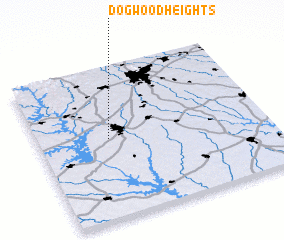 Places with similar names to Dogwood Heights, United States - USA ::
// Dogwood Heights (US)
// Dogwood Heights (US)
Disclaimer :: Information on this page comes without warranty of any kind |
||
|
Where is Dogwood Heights? Elevation and coordinates ::
Latitude (lat): 34°31'55"N Longitude (lon): 82°41'20"W
Elevation (approx.): 248m (map arrows pan, magnifying glasses zoom) |
||
|
Visiting Dogwood Heights? Hotel/Accommodation ::
Book a hotel in Dogwood Heights Travel Guide ::
rental cars ::
car rental offers GPS waypoint ::
download a GPX waypoint (PoI) of Dogwood Heights for your GPS receiver
|
||