|
search place name
|
||
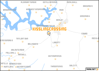
Kissling Crossing (Tennessee, United States - USA)Kissling Crossing is a town in the Tennessee region of United States - USA. An overview map of the region around Kissling Crossing is displayed below.
regional and 3d topo map of Kissling Crossing, United States - USA ::
Kissling Crossing airports ::
The nearest airport is HUA - Redstone Aaf, located 74.1 km south west of Kissling Crossing.
Other airports nearby include CHA - Chattanooga Lovell Fld (85.9 km east), BNA - Nashville Intl (117.1 km north west), ANB - Anniston Metro (177.0 km south), BHM - Birmingham Intl (187.0 km south), Nearby towns ::
Dry Creek Estates (2.8km north) //
Winchester (2.7km north east) //
Bel-Aire Heights (4.2km north east) //
Liberty (4.4km south east) //
Mountain View Acres (4.4km north east) //
Scenic Heights (4.5km north east) //
Myers (5.1km north) //
Keese (5.2km north east) //
Henley (5.8km north east) //
Murray Lake Estates (6.2km north) //
Belvidere (6.6km south west) //
Decherd (6.7km north east) //
Broadview (6.5km west) //
Eastbrook (7.9km north) //
Keith Springs (9.1km south) //
Asia (9.3km north east) //
Winchester Springs (9.7km north west) //
[all distances 'as the bird flies' and approximate]  Places with similar names to Kissling Crossing, United States - USA :: Disclaimer :: Information on this page comes without warranty of any kind |
||
|
Where is Kissling Crossing? Elevation and coordinates ::
Latitude (lat): 35°10'3"N Longitude (lon): 86°7'54"W
Elevation (approx.): 278m (map arrows pan, magnifying glasses zoom) |
||
|
Visiting Kissling Crossing? Hotel/Accommodation ::
Book a hotel in Kissling Crossing Travel Guide ::
rental cars ::
car rental offers GPS waypoint ::
download a GPX waypoint (PoI) of Kissling Crossing for your GPS receiver
|
||