|
search place name
|
||
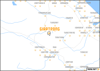
Giáp Trong (Vietnam)Giáp Trong is a town in Vietnam. An overview map of the region around Giáp Trong is displayed below.
regional and 3d topo map of Giáp Trong, Vietnam ::
Giáp Trong airports ::
The nearest airport is ZVK - Savannakhet, located 224.3 km south west of Giáp Trong.
Nearby towns ::
Tiêu Tương (1.9km north) //
Ðá Bạc (2.6km north east) //
Giáp Ngoai (2.6km north west) //
Ðại Ðồng (4.1km north east) //
Họ Hồ (4.1km north east) //
Tùng Nậy (4.1km north east) //
Thạch Lập Xá (4.1km north west) //
Phương Ðồng (4.1km north west) //
Trại Tràm (4.0km south east) //
Ma Rền (4.0km south east) //
Xóm Tranh (5.6km south) //
Mụ U (5.8km south) //
Xóm Tráng (5.8km south) //
Trại Cầu (5.6km east) //
Xóm Trọ Ðó (6.6km south west) //
Tùng Tràng (7.0km east) //
Rào Môc Xóm (7.4km south) //
Trại Bầu Nước (7.6km north) //
Xóm Côn Si (7.6km south) //
Xóm Ðá Có (7.6km south) //
Xóm Tro (7.6km south) //
Vong Liễu (7.7km south west) //
Bau Môn (7.7km south west) //
Xóm Nhai (8.2km south west) //
Trun Cà (9.0km north east) //
[all distances 'as the bird flies' and approximate]  Places with similar names to Giáp Trong, Vietnam ::
// Giáp Trung (VN)
Disclaimer :: Information on this page comes without warranty of any kind |
||
|
Where is Giáp Trong? Elevation and coordinates ::
Latitude (lat): 18°4'0"N Longitude (lon): 106°10'0"E
Elevation (approx.): 119m (map arrows pan, magnifying glasses zoom) |
||
|
Visiting Giáp Trong? Hotel/Accommodation ::
Book a hotel in Giáp Trong Travel Guide ::
Buy a travel guide for Vietnam rental cars ::
car rental offers GPS waypoint ::
download a GPX waypoint (PoI) of Giáp Trong for your GPS receiver
|
||