|
search place name
|
||
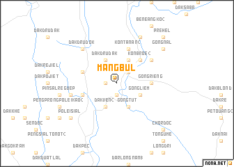
Mang Bul (Quảng Nam-Ðà Nẵng, Vietnam)Mang Bul is a town in the Quảng Nam-Ðà Nẵng region of Vietnam. An overview map of the region around Mang Bul is displayed below.
regional and 3d topo map of Mang Bul, Vietnam ::
Mang Bul airports ::
The nearest airport is DAD - Danang Intl, located 106.8 km north east of Mang Bul.
Nearby towns ::
Dak Rôtak (1.8km west) //
Gong Blôn (1.9km south) //
Dak Gle (2.6km north east) //
Dak Bla (2.6km north east) //
Dak Dru Dak (4.1km north west) //
Kon Broê (1) (4.1km north east) //
Dak Vên (1) (4.1km south west) //
Dak Vên (2) (4.1km south west) //
Gong Tut (4.1km south east) //
Gong Liêm (4.0km south east) //
Kon Broê (2) (5.2km north east) //
Gong Rieng (5.4km east) //
Dak Dru Dak (2) (5.7km west) //
Guga (5.7km west) //
Kon Tanan (2) (5.8km north) //
Kâlô (6.5km north east) //
Dak Trap (1) (7.4km west) //
Dak Dru Dok (7.7km north west) //
Kon Tanan (1) (8.2km north east) //
Pơlei Sial (9.1km south west) //
Gong Nal (9.1km north east) //
Préhel (10.3km north east) //
Chordoc (10.3km south east) //
[all distances 'as the bird flies' and approximate]  Places with similar names to Mang Bul, Vietnam ::
// Mangabol (PH)
// Mönkebüll (DE)
// Mongobolo (CF)
// Mangbala (CD)
// Mangbele (CD)
// Mongbali (CD)
// Mongobele (CD)
// Miniogbolo (SD)
// Moongobulla (AU)
// Munkebol (SE)
Disclaimer :: Information on this page comes without warranty of any kind |
||
|
Where is Mang Bul? Elevation and coordinates ::
Latitude (lat): 15°10'0"N Longitude (lon): 107°47'0"E
Elevation (approx.): 945m (map arrows pan, magnifying glasses zoom) |
||
|
Visiting Mang Bul? Hotel/Accommodation ::
Book a hotel in Mang Bul Travel Guide ::
Buy a travel guide for Vietnam rental cars ::
car rental offers GPS waypoint ::
download a GPX waypoint (PoI) of Mang Bul for your GPS receiver
|
||