|
search place name
|
||
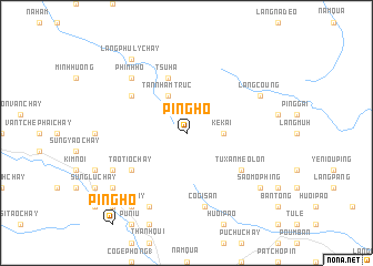
Ping Ho (Vietnam)Ping Ho is a town in Vietnam. An overview map of the region around Ping Ho is displayed below.
regional and 3d topo map of Ping Ho, Vietnam ::
Ping Ho airports ::
The nearest airport is HAN - Hanoi Noibai Intl, located 181.9 km south east of Ping Ho.
Nearby towns ::
Ké Kai (3.4km east) //
Tân Nham Trúc (4.1km north west) //
Tsu Hà (5.8km north) //
Tao Tio Chay (6.4km south west) //
Tu Xan Mèo Lón (6.4km south east) //
Mu Pi Phung (6.4km north west) //
Co Gi San (7.6km south) //
Phinh Hồ (7.6km north west) //
Dan Kai Ho (7.6km north west) //
Pu Niu Suối Tao (8.2km south west) //
Nga Yang Chay (2) (8.2km south west) //
Ho Suối Tao (7.8km south west) //
Làng Coung (7.8km north east) //
Nga Yang Chay (1) (9.0km south west) //
Sao Chay (9.0km south west) //
Làng Phú Lý Chây (9.0km north west) //
Mao Mu San Chay (8.8km south west) //
Ma Sa Ho (8.8km south west) //
Sao Mo Phing (8.8km south east) //
Ku Bao Chay (10.1km south west) //
[all distances 'as the bird flies' and approximate] 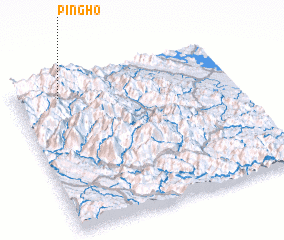 Places with similar names to Ping Ho, Vietnam ::
Disclaimer :: Information on this page comes without warranty of any kind |
||
|
Where is Ping Ho? Elevation and coordinates ::
Latitude (lat): 21°53'0"N Longitude (lon): 104°12'0"E
Elevation (approx.): 2150m (map arrows pan, magnifying glasses zoom) |
||
|
Visiting Ping Ho? Hotel/Accommodation ::
Book a hotel in Ping Ho Travel Guide ::
Buy a travel guide for Vietnam rental cars ::
car rental offers GPS waypoint ::
download a GPX waypoint (PoI) of Ping Ho for your GPS receiver
|
||