|
search place name
|
||
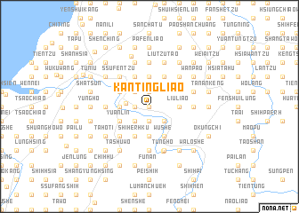
K'an-ting-liao (T'ai-wan, Taiwan)K'an-ting-liao is a town in the T'ai-wan region of Taiwan. An overview map of the region around K'an-ting-liao is displayed below.
regional and 3d topo map of K'an-ting-liao, Taiwan ::
K'an-ting-liao airports ::
The nearest airport is TPE - Taipei Chiang Kai Shek Intl, located 53.7 km north east of K'an-ting-liao.
Other airports nearby include TSA - Taipei Sungshan (74.0 km north east), HUN - Hualien (94.7 km south east), CYI - Chiayi (144.7 km south west), MZG - Makung Magong (182.5 km south west), Nearby towns ::
Shang-pei-wan (0.0km north) //
Ta-pei-pu (1.7km west) //
Pei-pu (1.7km west) //
Wai-ssu-wan (1.9km south) //
Ssu-wan (1.9km south) //
Shih-erh-liao (1.9km north) //
Hsiao-nan-pu (2.5km south west) //
Ta-nan-pu (2.5km south west) //
Ting-liao (2.5km north west) //
T'ung-lo-ch'üan (2.5km north west) //
T'ien-wei (2.5km south east) //
Lung-men-k'ou (2.5km south east) //
San-wan (2.7km west) //
Shui-lung (3.4km west) //
Ta-hu (3.7km south) //
Hsiao-hu-shan (3.7km south) //
Hsi-hu (3.7km south) //
Hsiung-chiao-hu (3.7km south) //
Shih-wu-liao (3.7km north) //
Hsi-mao-pu (3.7km north) //
Fu-hsin (3.7km north) //
Liu-liao (3.4km east) //
Shih-erh-ku (4.1km south west) //
Chih-liao-hsia (4.1km south west) //
Hsiung-lin-chiao (4.1km north west) //
Shih-k'eng-tzu (4.1km north west) //
Hsi-ho-p'ai (4.1km north west) //
T'o-shan-tzu (3.8km south west) //
T'un-ying (3.8km south west) //
[all distances 'as the bird flies' and approximate]  Places with similar names to K'an-ting-liao, Taiwan ::
// Candañgal (PH)
// Kundang Ulu (MY)
// Kindungula (CD)
// K'ŭnt'ong-gol (KP)
// Kon Ton Klah (VN)
// Quindungula (AO)
// Gôndangale (MM)
// Kindangale (MM)
// Kundainggale (MM)
// Quintungul (GW)
Disclaimer :: Information on this page comes without warranty of any kind |
||
|
Where is K'an-ting-liao? Elevation and coordinates ::
Latitude (lat): 24°39'0"N Longitude (lon): 120°59'0"E
Elevation (approx.): 167m (map arrows pan, magnifying glasses zoom) |
||
|
Visiting K'an-ting-liao? Hotel/Accommodation ::
Book a hotel in K'an-ting-liao Travel Guide ::
Buy a travel guide for Taiwan rental cars ::
car rental offers GPS waypoint ::
download a GPX waypoint (PoI) of K'an-ting-liao for your GPS receiver
|
||