|
search place name
|
||
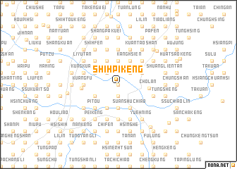
Shih-pi-k'eng (T'ai-wan, Taiwan)Shih-pi-k'eng is a town in the T'ai-wan region of Taiwan. An overview map of the region around Shih-pi-k'eng is displayed below.
regional and 3d topo map of Shih-pi-k'eng, Taiwan ::
Shih-pi-k'eng airports ::
The nearest airport is HUN - Hualien, located 90.8 km east of Shih-pi-k'eng.
Other airports nearby include TPE - Taipei Chiang Kai Shek Intl (95.8 km north east), CYI - Chiayi (102.7 km south west), TSA - Taipei Sungshan (114.1 km north east), MZG - Makung Magong (143.8 km south west), Nearby towns ::
Ta-pu-yüan (0.0km north) //
Shih-pi-k'eng-k'ou (1.9km south) //
Chao-lan-ch'i (1.9km south) //
Kuo-ti-k'o (1.9km south) //
Ai-shan (2.5km north west) //
San-kuei-k'eng (2.5km north west) //
Pu-wei (2.5km north east) //
Shih-fen (3.7km north) //
Suan-kan-hu (3.7km north) //
Shih-ch'eng (3.7km south) //
Shih-wei-ch'iang (3.7km south) //
T'ai-an (3.9km north west) //
Li-yü-t'an (3.9km north west) //
Ch'i-kuei-k'eng (4.1km north west) //
Niu-ch'ou-k'eng (3.9km south west) //
Kang-hsien (4.1km north east) //
Shih-kang (4.1km south west) //
Chiu-fang-ts'o (4.1km south west) //
Hsi-p'ing (3.9km north east) //
Feng-t'ien-li (3.9km north east) //
Hsing-lung (4.1km south east) //
Suan-shu-chiao (4.1km south east) //
Ta-p'ai (4.1km south east) //
Cho-lan (4.4km east) //
Nan-p'ien-shan-hsia (5.0km north west) //
Sheng-ch'i (5.0km north west) //
Shang-shan-chiao (5.0km north west) //
Fan-tzu-ch'eng (5.0km north west) //
P'i-t'ou (5.0km south west) //
[all distances 'as the bird flies' and approximate]  Places with similar names to Shih-pi-k'eng, Taiwan ::
// Shapahkang (MM)
// Chupacanca (PE)
// Chih-po-k'eng (TW)
// Shih-p'ai-k'eng (TW)
// Shih-p'o-k'eng (TW)
// Hsia-po-kung (TW)
// Hsiao-pei-k'eng (TW)
// Hsiao-pei-k'eng (TW)
// Shu-pai-kung (TW)
Disclaimer :: Information on this page comes without warranty of any kind |
||
|
Where is Shih-pi-k'eng? Elevation and coordinates ::
Latitude (lat): 24°19'0"N Longitude (lon): 120°47'0"E
Elevation (approx.): 282m (map arrows pan, magnifying glasses zoom) |
||
|
Visiting Shih-pi-k'eng? Hotel/Accommodation ::
Book a hotel in Shih-pi-k'eng Travel Guide ::
Buy a travel guide for Taiwan rental cars ::
car rental offers GPS waypoint ::
download a GPX waypoint (PoI) of Shih-pi-k'eng for your GPS receiver
|
||