|
search place name
|
||
Wu-tung-li (T'ai-wan, Taiwan)Wu-tung-li is a town in the T'ai-wan region of Taiwan. An overview map of the region around Wu-tung-li is displayed below.
regional and 3d topo map of Wu-tung-li, Taiwan ::

Wu-tung-li airports ::
The nearest airport is CYI - Chiayi, located 54.4 km south west of Wu-tung-li.
Other airports nearby include HUN - Hualien (101.1 km east), MZG - Makung Magong (108.8 km west), TNN - Tainan (113.9 km south west), WOT - Wang An (130.1 km south west), Nearby towns ::
Heng-shan (0.0km north) //
Nan-p'ing (0.0km north) //
Pu-hsia (1.9km south) //
Lu-ming (1.9km south) //
Pan-ling (1.7km east) //
Wu-hsi (1.9km north) //
Shih-ts'o-p'ing (1.9km north) //
Wu-tung (1.9km north) //
Pu-hsia-ts'un (2.5km south west) //
Feng-ming (3.3km north) //
Jen-ho (3.1km north west) //
Chu-wei (3.7km south) //
Ch'ih-shui (3.7km south) //
Chin-tzu (3.7km south) //
Lan-k'ou-tien-tzu (3.7km south) //
Ts'ao-ling (3.7km north) //
Wa-kuo-liao (3.7km north) //
Hsi-ling-li (3.7km north) //
Liu-fen-liao (3.7km north) //
Pi-shan-yen (3.7km north) //
Shan-hu-ts'un (3.4km west) //
Ch'ao-hsing (3.4km west) //
Hsü-ts'o-liao (3.4km west) //
Ch'ing-shui-ts'un (3.4km west) //
Min-ch'üan-hsin-ts'un (3.4km east) //
Ta-chuang (3.7km south east) //
Ching-tzu-t'ou (4.1km south west) //
Fu-ch'i (4.1km south west) //
Ch'ih-shui (4.1km south west) //
[all distances 'as the bird flies' and approximate] 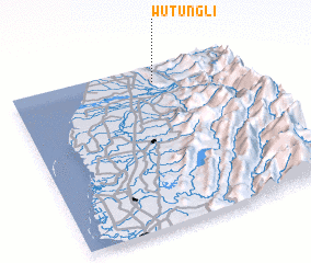 Places with similar names to Wu-tung-li, Taiwan ::
Disclaimer :: Information on this page comes without warranty of any kind |
||
|
Where is Wu-tung-li? Elevation and coordinates ::
Latitude (lat): 23°54'0"N Longitude (lon): 120°38'0"E
Elevation (approx.): 407m (map arrows pan, magnifying glasses zoom) |
||
|
Visiting Wu-tung-li? Hotel/Accommodation ::
Book a hotel in Wu-tung-li Travel Guide ::
Buy a travel guide for Taiwan rental cars ::
car rental offers GPS waypoint ::
download a GPX waypoint (PoI) of Wu-tung-li for your GPS receiver
|
||