|
search place name
|
||
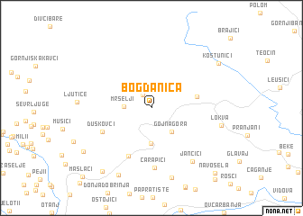
Bogdanica (Srbija, Serbia and Montenegro)Bogdanica is a town in the Srbija region of Serbia and Montenegro. An overview map of the region around Bogdanica is displayed below.
regional and 3d topo map of Bogdanica, Serbia and Montenegro ::
Bogdanica airports ::
The nearest airport is BEG - Beograd, located 90.7 km north of Bogdanica.
Other airports nearby include SJJ - Sarajevo (144.0 km west), INI - Nis (159.9 km south east), PRN - Pristina (177.2 km south east), OSI - Osijek (190.8 km north west), Nearby towns ::
Pavlovici (1.8km north west) //
Mršelji (2.5km west) //
Gojna Gora (3.5km south east) //
Šumljakovina (4.4km south) //
Družetići (4.2km east) //
Gornja Dobrinja (6.4km south) //
Duškovci (5.3km south west) //
Čarapići (7.5km south) //
Jančići (7.6km south east) //
Lokva (6.6km east) //
Gornji Karanci (8.8km south) //
Srednja Dobrinja (8.8km south) //
Koštunići (8.1km north east) //
Mađer (9.0km south west) //
Ježevica (8.1km south west) //
Navosela (9.9km south east) //
Kamenica (10.5km south east) //
Maslaći (10.5km south west) //
[all distances 'as the bird flies' and approximate] 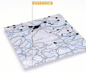 Places with similar names to Bogdanica, Serbia and Montenegro ::
Disclaimer :: Information on this page comes without warranty of any kind |
||
|
Where is Bogdanica? Elevation and coordinates ::
Latitude (lat): 44°0'55"N Longitude (lon): 20°6'18"E
Elevation (approx.): 475m (map arrows pan, magnifying glasses zoom) |
||
|
Visiting Bogdanica? Hotel/Accommodation ::
Book a hotel in Bogdanica Travel Guide ::
rental cars ::
car rental offers GPS waypoint ::
download a GPX waypoint (PoI) of Bogdanica for your GPS receiver
|
||