|
search place name
|
||
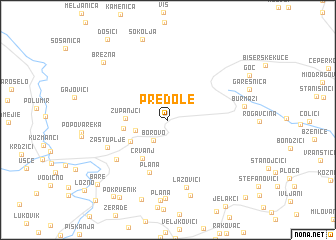
Predole (Srbija, Serbia and Montenegro)Predole is a town in the Srbija region of Serbia and Montenegro. An overview map of the region around Predole is displayed below.
regional and 3d topo map of Predole, Serbia and Montenegro ::
Predole airports ::
The nearest airport is INI - Nis, located 91.8 km east of Predole.
Other airports nearby include PRN - Pristina (106.6 km south), BEG - Beograd (149.7 km north), TGD - Podgorica (176.5 km south west), SKP - Skopje (186.2 km south east), Nearby towns ::
Borovo (2.6km south west) //
Ravni (2.9km south west) //
Zupanjci (3.5km west) //
Međurečje (3.8km south west) //
Gokčanica (3.7km west) //
Rudnjak (3.7km west) //
Crvanj (4.7km south west) //
Plana (6.1km south) //
Dobra Bukva (6.1km south west) //
Zastuplje (5.8km south west) //
Lazovići (7.7km south) //
Kovači (8.7km south) //
Burmazi (6.4km east) //
Boće (8.6km south) //
Koprivnica (9.1km south) //
Brezna (8.3km north west) //
Pokrvenik (9.5km south west) //
Biljanovac (9.6km south west) //
Bare (9.2km south west) //
Lazarevići (10.7km south east) //
[all distances 'as the bird flies' and approximate]  Places with similar names to Predole, Serbia and Montenegro ::
Disclaimer :: Information on this page comes without warranty of any kind |
||
|
Where is Predole? Elevation and coordinates ::
Latitude (lat): 43°30'30"N Longitude (lon): 20°44'41"E
Elevation (approx.): 775m (map arrows pan, magnifying glasses zoom) |
||
|
Visiting Predole? Hotel/Accommodation ::
Book a hotel in Predole Travel Guide ::
rental cars ::
car rental offers GPS waypoint ::
download a GPX waypoint (PoI) of Predole for your GPS receiver
|
||