|
search place name
|
||
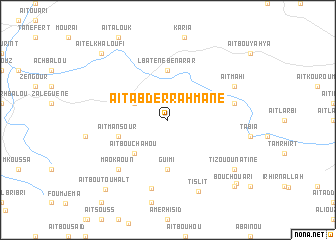
Aït Abd er Rahmane (Azilal, Morocco)Aït Abd er Rahmane is a town in the Azilal region of Morocco. An overview map of the region around Aït Abd er Rahmane is displayed below.
regional and 3d topo map of Aït Abd er Rahmane, Morocco ::
Aït Abd er Rahmane airports ::
The nearest airport is RAK - Marrakech Menara, located 119.7 km south west of Aït Abd er Rahmane.
Other airports nearby include OZZ - Ouarzazate (123.2 km south), CMN - Casablanca Mohammed V Intl (160.4 km north west), MEK - Meknes Bassatine (239.8 km north east), FEZ - Fez Saiss (274.0 km north east), Nearby towns ::
Askomber (3.6km north west) //
Aït Bouchahou (4.9km south west) //
Guimi (5.6km south) //
Lbatene Ben Arar (5.6km north) //
Aït Mansour (5.1km west) //
Tamzerout (6.6km east) //
Tiharissine (7.8km south) //
Maokaoun (7.3km south west) //
Aït Mahi (7.3km north east) //
Tislit (8.5km south) //
Tizou Ounatine (8.4km south east) //
Aït Sellam (9.6km south east) //
Aït Bou Touhalt (9.8km south west) //
Bou Chouari (9.7km south east) //
Aït el Khaloufi (9.7km north west) //
[all distances 'as the bird flies' and approximate]  Places with similar names to Aït Abd er Rahmane, Morocco :: Disclaimer :: Information on this page comes without warranty of any kind |
||
|
Where is Aït Abd er Rahmane? Elevation and coordinates ::
Latitude (lat): 32°3'0"N Longitude (lon): 6°53'0"W
Elevation (approx.): 776m (map arrows pan, magnifying glasses zoom) |
||
|
Visiting Aït Abd er Rahmane? Hotel/Accommodation ::
Book a hotel in Aït Abd er Rahmane Travel Guide ::
Buy a travel guide for Morocco rental cars ::
car rental offers GPS waypoint ::
download a GPX waypoint (PoI) of Aït Abd er Rahmane for your GPS receiver
|
||