|
search place name
|
||
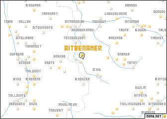
Aït Ben Amer (Marrakech, Morocco)Aït Ben Amer is a town in the Marrakech region of Morocco. An overview map of the region around Aït Ben Amer is displayed below.
regional and 3d topo map of Aït Ben Amer, Morocco ::
Aït Ben Amer airports ::
The nearest airport is OZZ - Ouarzazate, located 65.5 km south east of Aït Ben Amer.
Other airports nearby include RAK - Marrakech Menara (67.5 km north west), Nearby towns ::
Tadert (0.9km south west) //
Tilnif (1.6km west) //
Tazzouguert (4.0km north west) //
Iziks (4.3km south east) //
Afra (4.6km south west) //
Amekha (4.4km west) //
Isirhs (4.9km south east) //
Titdri (4.7km east) //
Immouzer (5.6km south) //
Arg nʼ Ouʼannou (5.6km north) //
Tidsi (5.1km west) //
Tamezmout (6.3km east) //
Aït Mansour (7.6km north) //
Asats (6.6km west) //
Zerkten (7.7km north) //
Amesmsa (7.3km north east) //
Tagmout (8.1km north east) //
Tabahggat (8.1km north west) //
Tazliada (8.6km north west) //
[all distances 'as the bird flies' and approximate]  Places with similar names to Aït Ben Amer, Morocco ::
// Aït Ben Omar (MA)
Disclaimer :: Information on this page comes without warranty of any kind |
||
|
Where is Aït Ben Amer? Elevation and coordinates ::
Latitude (lat): 31°22'0"N Longitude (lon): 7°23'0"W
Elevation (approx.): 1653m (map arrows pan, magnifying glasses zoom) |
||
|
Visiting Aït Ben Amer? Hotel/Accommodation ::
Book a hotel in Aït Ben Amer Travel Guide ::
Buy a travel guide for Morocco rental cars ::
car rental offers GPS waypoint ::
download a GPX waypoint (PoI) of Aït Ben Amer for your GPS receiver
|
||