|
search place name
|
||
Am Aktâne (Al Hoceïma, Morocco)Am Aktâne is a town in the Al Hoceïma region of Morocco. An overview map of the region around Am Aktâne is displayed below.
regional and 3d topo map of Am Aktâne, Morocco ::

Am Aktâne airports ::
The nearest airport is AHU - Al Hociema Cherif El Idrissi, located 67.8 km north east of Am Aktâne.
Other airports nearby include FEZ - Fez Saiss (112.6 km south west), TTU - Tetouan Saniat Rmel (113.4 km north west), MEK - Meknes Bassatine (144.6 km south west), MLN - Melilla (145.8 km east), Nearby towns ::
Amadene (1.5km east) //
Tattarene (2.4km south east) //
Iberkchichene (2.4km south east) //
Merad (3.0km east) //
Aarabene (4.0km north) //
Ed Deï (3.6km north east) //
Louta (3.6km south east) //
Zerkat (3.6km south east) //
Arabene (4.8km north west) //
Irhariane (4.8km north east) //
El Knatene (4.6km east) //
Adouz (4.6km east) //
Ikhadirene (5.8km north) //
Igraimgene (4.9km east) //
Bou Atta (5.9km north east) //
Aït Teimane (6.3km north east) //
Azila (6.1km west) //
Andarfo (6.1km east) //
Tiguisa (6.4km west) //
Tafsou (7.6km south) //
Asenso (8.7km south east) //
Aït Solimane (9.6km south west) //
[all distances 'as the bird flies' and approximate] 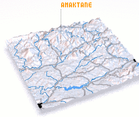 Places with similar names to Am Aktâne, Morocco ::
// Amakhton (RU)
// Amégadiani (TG)
Disclaimer :: Information on this page comes without warranty of any kind |
||
|
Where is Am Aktâne? Elevation and coordinates ::
Latitude (lat): 34°51'0"N Longitude (lon): 4°28'0"W
Elevation (approx.): 1696m (map arrows pan, magnifying glasses zoom) |
||
|
Visiting Am Aktâne? Hotel/Accommodation ::
Book a hotel in Am Aktâne Travel Guide ::
Buy a travel guide for Morocco rental cars ::
car rental offers GPS waypoint ::
download a GPX waypoint (PoI) of Am Aktâne for your GPS receiver
|
||