|
search place name
|
||
Asilah (Tanger, Morocco)Asilah is a town in the Tanger region of Morocco. An overview map of the region around Asilah is displayed below.
regional and 3d topo map of Asilah, Morocco ::

Asilah airports ::
The nearest airport is TNG - Tanger Ibn Batouta, located 31.1 km north of Asilah.
Other airports nearby include TTU - Tetouan Saniat Rmel (66.9 km east), GIB - Gibraltar (98.4 km north east), NNA - Kentira Kenitra (139.0 km south), XRY - Jerez (141.9 km north), Nearby towns ::
Draliyne (2.7km north east) //
Oulad Sbaïta (3.6km east) //
Ed Dechiouar (4.3km south east) //
Aïssa er Rifi (4.0km south east) //
Bouferrah (4.3km south east) //
Hafa (4.1km east) //
Tendafel (5.6km south) //
Ej Jelaoula (4.9km east) //
El Akba (6.3km south) //
Dar es Sied (5.5km east) //
El Hamar (7.6km south) //
Demina (7.7km south) //
Oulad Abbou (6.7km south east) //
Oulad el Mehdi (7.7km north east) //
Er Riaïna (7.7km south east) //
Douar Chrif (8.8km north east) //
Aouazra (9.5km south east) //
Brenna (9.7km south east) //
[all distances 'as the bird flies' and approximate] 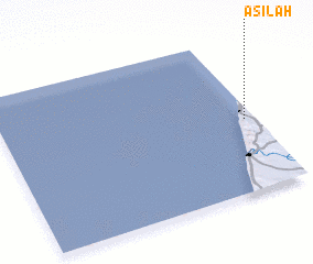 Places with similar names to Asilah, Morocco ::
Disclaimer :: Information on this page comes without warranty of any kind |
||
|
Where is Asilah? Elevation and coordinates ::
Latitude (lat): 35°27'56"N Longitude (lon): 6°2'25"W
Elevation (approx.): 15m (map arrows pan, magnifying glasses zoom) |
||
|
Visiting Asilah? Hotel/Accommodation ::
Book a hotel in Asilah Travel Guide ::
Buy a travel guide for Morocco rental cars ::
car rental offers GPS waypoint ::
download a GPX waypoint (PoI) of Asilah for your GPS receiver
|
||