|
search place name
|
||
Dar Caïd Driss (Sidi Kacem, Morocco)Dar Caïd Driss is a town in the Sidi Kacem region of Morocco. An overview map of the region around Dar Caïd Driss is displayed below.
regional and 3d topo map of Dar Caïd Driss, Morocco ::

Dar Caïd Driss airports ::
The nearest airport is NNA - Kentira Kenitra, located 50.8 km west of Dar Caïd Driss.
Other airports nearby include MEK - Meknes Bassatine (71.8 km south east), RBA - Rabat Sale (72.9 km south west), FEZ - Fez Saiss (109.3 km south east), TNG - Tanger Ibn Batouta (153.1 km north), Nearby towns ::
Sidi Moussa Ben Ali (2.5km north) //
Oulad Saïd (2.6km south) //
Cheïkh Mohammed Ben el Ouati (2.9km east) //
El Khemmar (4.0km north west) //
Douar Cherkaoua (5.0km south east) //
Oulad Aïssa (5.2km south west) //
Chraouta (6.0km north west) //
Ksebia (7.0km south) //
Lalla Mira (7.3km north) //
Garat (7.4km north) //
Oulad Moussa (6.9km north east) //
Mechta Sidi Amar (7.0km north east) //
Douar el Caïd el Gueddari (8.5km north west) //
Ouled Hammar (8.7km north west) //
Dar el Baraka (11.4km north west) //
[all distances 'as the bird flies' and approximate] 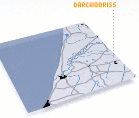 Places with similar names to Dar Caïd Driss, Morocco ::
Disclaimer :: Information on this page comes without warranty of any kind |
||
|
Where is Dar Caïd Driss? Elevation and coordinates ::
Latitude (lat): 34°21'5"N Longitude (lon): 6°2'52"W
Elevation (approx.): 18m (map arrows pan, magnifying glasses zoom) |
||
|
Visiting Dar Caïd Driss? Hotel/Accommodation ::
Book a hotel in Dar Caïd Driss Travel Guide ::
Buy a travel guide for Morocco rental cars ::
car rental offers GPS waypoint ::
download a GPX waypoint (PoI) of Dar Caïd Driss for your GPS receiver
|
||