|
search place name
|
||
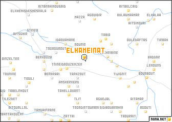
El Hameinat (Essaouira, Morocco)El Hameinat is a town in the Essaouira region of Morocco. An overview map of the region around El Hameinat is displayed below.
regional and 3d topo map of El Hameinat, Morocco ::
El Hameinat airports ::
The nearest airport is AGA - Agadir Inezgane, located 104.5 km south of El Hameinat.
Other airports nearby include RAK - Marrakech Menara (124.8 km east), Nearby towns ::
Annzig (2.8km north) //
Aourir (2.9km north west) //
Tarhzout (4.0km south west) //
Tnine Ida Ou Zemzem (4.0km south west) //
Toukhribine (4.2km east) //
Tinift (5.2km north east) //
Tassila (4.8km east) //
Ijoumalene (5.1km west) //
Tiourat (5.8km south) //
Ida Ou Amane (5.4km north west) //
Tabia (6.0km north east) //
Amskerkerd (6.4km south west) //
Bou Addou (6.0km north east) //
Tagaouaout (5.8km west) //
Aghbalou (5.9km east) //
Tahellouant (8.1km south west) //
Berhrari (7.3km south west) //
Tijignit (7.3km south east) //
Mazza (8.9km north) //
[all distances 'as the bird flies' and approximate] 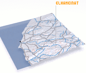 Places with similar names to El Hameinat, Morocco ::
// El Hamanda (MA)
// El Hamouinat (MA)
Disclaimer :: Information on this page comes without warranty of any kind |
||
|
Where is El Hameinat? Elevation and coordinates ::
Latitude (lat): 31°18'0"N Longitude (lon): 9°18'0"W
Elevation (approx.): 681m (map arrows pan, magnifying glasses zoom) |
||
|
Visiting El Hameinat? Hotel/Accommodation ::
Book a hotel in El Hameinat Travel Guide ::
Buy a travel guide for Morocco rental cars ::
car rental offers GPS waypoint ::
download a GPX waypoint (PoI) of El Hameinat for your GPS receiver
|
||