|
search place name
|
||
Guimi (Azilal, Morocco)Guimi is a town in the Azilal region of Morocco. An overview map of the region around Guimi is displayed below.
regional and 3d topo map of Guimi, Morocco ::

Guimi airports ::
The nearest airport is RAK - Marrakech Menara, located 117.6 km west of Guimi.
Other airports nearby include OZZ - Ouarzazate (117.7 km south), CMN - Casablanca Mohammed V Intl (165.5 km north west), MEK - Meknes Bassatine (244.5 km north east), FEZ - Fez Saiss (278.2 km north east), Nearby towns ::
Tiharissine (2.6km south west) //
Aït Ouichouane (4.0km south west) //
Aït Bouchahou (3.6km north west) //
Tislit (3.8km south east) //
Aït Abd er Rahmane (5.6km north) //
Maokaoun (4.7km west) //
Amerhisid (5.6km south) //
Aït Mansour (6.0km north west) //
Aït Bou Touhalt (6.3km west) //
Tizou Ounatine (6.3km east) //
Tikiyout (7.1km south west) //
Bou Chouari (6.6km east) //
Aït Bouhou (7.6km south) //
Aït Sellam (6.7km east) //
Aït Boulmane (7.3km south west) //
Aït Tagant (7.3km south west) //
Askomber (8.1km north west) //
Aït Souss (8.4km south west) //
Tamzerout (9.7km north east) //
[all distances 'as the bird flies' and approximate] 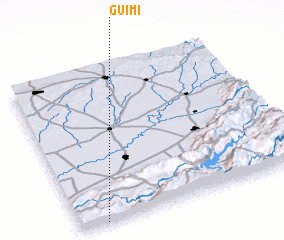 Places with similar names to Guimi, Morocco ::
Disclaimer :: Information on this page comes without warranty of any kind |
||
|
Where is Guimi? Elevation and coordinates ::
Latitude (lat): 32°0'0"N Longitude (lon): 6°53'0"W
Elevation (approx.): 728m (map arrows pan, magnifying glasses zoom) |
||
|
Visiting Guimi? Hotel/Accommodation ::
Book a hotel in Guimi Travel Guide ::
Buy a travel guide for Morocco rental cars ::
car rental offers GPS waypoint ::
download a GPX waypoint (PoI) of Guimi for your GPS receiver
|
||