|
search place name
|
||
Oulad Filala (Taza, Morocco)Oulad Filala is a town in the Taza region of Morocco. An overview map of the region around Oulad Filala is displayed below.
regional and 3d topo map of Oulad Filala, Morocco ::

Oulad Filala airports ::
The nearest airport is AHU - Al Hociema Cherif El Idrissi, located 73.7 km north east of Oulad Filala.
Other airports nearby include FEZ - Fez Saiss (102.1 km south west), MLN - Melilla (137.4 km north east), MEK - Meknes Bassatine (144.2 km south west), TTU - Tetouan Saniat Rmel (151.7 km north west), Nearby towns ::
Oulad Driouach (1.5km west) //
Ahl Imoula (2.4km south east) //
El Araba (2.4km north east) //
Beni Krama (4.0km south) //
El Menzel (4.0km north) //
El Anser (4.8km north east) //
Dar Caïd Taïeb (5.8km south) //
Zaouia (6.3km north west) //
Sidi Daoud (6.4km west) //
Koudia (7.2km north east) //
Oulad Bachir (7.2km south west) //
Zourek (7.1km south east) //
Taïneste (7.1km south east) //
Bab Taddert (7.1km north west) //
Oulad Fryakh (8.3km north west) //
Ziaïna (8.3km south west) //
Kef el Rhar (9.6km south west) //
Es Smamda (9.6km south west) //
Tounes (9.6km north west) //
Tahar Souk (9.6km north west) //
[all distances 'as the bird flies' and approximate] 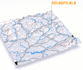 Places with similar names to Oulad Filala, Morocco :: Disclaimer :: Information on this page comes without warranty of any kind |
||
|
Where is Oulad Filala? Elevation and coordinates ::
Latitude (lat): 34°35'0"N Longitude (lon): 4°12'0"W
Elevation (approx.): 762m (map arrows pan, magnifying glasses zoom) |
||
|
Visiting Oulad Filala? Hotel/Accommodation ::
Book a hotel in Oulad Filala Travel Guide ::
Buy a travel guide for Morocco rental cars ::
car rental offers GPS waypoint ::
download a GPX waypoint (PoI) of Oulad Filala for your GPS receiver
|
||