|
search place name
|
||
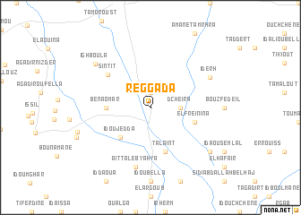
Reggada (Tiznit, Morocco)Reggada is a town in the Tiznit region of Morocco. An overview map of the region around Reggada is displayed below.
regional and 3d topo map of Reggada, Morocco ::
Reggada airports ::
The nearest airport is AGA - Agadir Inezgane, located 89.7 km north of Reggada.
Other airports nearby include TTA - Tan Tan Plage Blanche (190.0 km south west), TIN - Tindouf (256.9 km south east), Nearby towns ::
El Kseïb (1.9km north) //
Dcheïra (3.2km east) //
Id Ou Jedda (4.9km south west) //
Ben Aomar (4.8km west) //
El Freïnina (5.2km east) //
Talaïnt (5.8km south) //
Sintit (6.2km north west) //
Aït Taleb Yahya (7.6km south) //
Iderh (7.4km north east) //
Ighboula (8.0km north west) //
Id Bou Abane (8.5km south east) //
[all distances 'as the bird flies' and approximate] 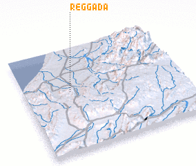 Places with similar names to Reggada, Morocco ::
Disclaimer :: Information on this page comes without warranty of any kind |
||
|
Where is Reggada? Elevation and coordinates ::
Latitude (lat): 29°35'0"N Longitude (lon): 9°42'0"W
Elevation (approx.): 377m (map arrows pan, magnifying glasses zoom) |
||
|
Visiting Reggada? Hotel/Accommodation ::
Book a hotel in Reggada Travel Guide ::
Buy a travel guide for Morocco rental cars ::
car rental offers GPS waypoint ::
download a GPX waypoint (PoI) of Reggada for your GPS receiver
|
||