|
search place name
|
||
Sint (Taroudannt, Morocco)Sint is a town in the Taroudannt region of Morocco. An overview map of the region around Sint is displayed below.
regional and 3d topo map of Sint, Morocco ::

Sint airports ::
The nearest airport is AGA - Agadir Inezgane, located 76.2 km north west of Sint.
Other airports nearby include RAK - Marrakech Menara (185.3 km north east), OZZ - Ouarzazate (207.6 km north east), Nearby towns ::
Tagraga (0.0km north) //
Tanamert (0.0km north) //
Toufla azet (1.9km south) //
Aït Ouiddirene (3.7km south) //
Agzemir (3.2km east) //
Anamer (3.2km west) //
Iouzlit (3.7km north) //
Tazrout (4.0km south east) //
Amdouz (4.0km north east) //
Sri (4.9km south east) //
Tifrhelt nʼTimigat (4.8km east) //
Tagounit (4.8km east) //
Tifrhelt (5.6km south) //
Inefguene (5.8km north) //
Tagmout (5.2km west) //
Taïart (5.8km north) //
Igdi (6.1km south east) //
Aguerd nʼ Imelil (6.1km south east) //
Tabia (6.1km south west) //
Kemaz (6.1km north east) //
Aït Hammou (6.4km north west) //
Oualmou (6.4km north west) //
Aït Bou Youssef (6.4km west) //
Takerbount (6.7km east) //
Anamer (7.6km south) //
Oukhliessene (7.6km north) //
Tamjicht (7.4km south east) //
Tiguedi (7.4km south east) //
Mahfoud (8.1km south west) //
[all distances 'as the bird flies' and approximate] 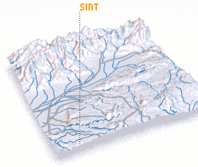 Places with similar names to Sint, Morocco ::
Disclaimer :: Information on this page comes without warranty of any kind |
||
|
Where is Sint? Elevation and coordinates ::
Latitude (lat): 30°5'0"N Longitude (lon): 8°50'0"W
Elevation (approx.): 1264m (map arrows pan, magnifying glasses zoom) |
||
|
Visiting Sint? Hotel/Accommodation ::
Book a hotel in Sint Travel Guide ::
Buy a travel guide for Morocco rental cars ::
car rental offers GPS waypoint ::
download a GPX waypoint (PoI) of Sint for your GPS receiver
|
||