|
search place name
|
||
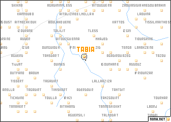
Tabia (Marrakech, Morocco)Tabia is a town in the Marrakech region of Morocco. An overview map of the region around Tabia is displayed below.
regional and 3d topo map of Tabia, Morocco ::
Tabia airports ::
The nearest airport is RAK - Marrakech Menara, located 84.6 km north east of Tabia.
Other airports nearby include AGA - Agadir Inezgane (114.1 km south west), OZZ - Ouarzazate (175.4 km east), Nearby towns ::
Ifrane nʼ Sidi Bouzid (1.9km north) //
Msafer (3.7km north east) //
Mhajed (4.9km north east) //
Aït Ouzguenna (4.9km north west) //
Igourhane (5.1km east) //
Tless (5.8km north) //
Ouines (5.1km west) //
Arhelane (5.1km east) //
Lalla Aziza (6.4km south east) //
Lalla Tensaït (6.0km north west) //
Agadir Ouazeg (6.3km east) //
Aderdour (7.4km south) //
Iguernali (6.3km west) //
Tamsdart (6.3km west) //
Taddart (6.6km east) //
Ourguioum (6.6km west) //
Talilit (7.3km north west) //
Timiskert (8.8km south west) //
Bou Lahouene (8.8km north west) //
Talat Ourhiat (8.4km north west) //
Tagadirt (8.4km south west) //
Iloujanene (8.4km north west) //
Iboujane el Mellah (8.4km north west) //
Tamtdit (9.8km south east) //
Agouni (9.8km north east) //
Kattos (9.8km north east) //
[all distances 'as the bird flies' and approximate]  Places with similar names to Tabia, Morocco ::
Disclaimer :: Information on this page comes without warranty of any kind |
||
|
Where is Tabia? Elevation and coordinates ::
Latitude (lat): 31°8'0"N Longitude (lon): 8°44'0"W
Elevation (approx.): 1066m (map arrows pan, magnifying glasses zoom) |
||
|
Visiting Tabia? Hotel/Accommodation ::
Book a hotel in Tabia Travel Guide ::
Buy a travel guide for Morocco rental cars ::
car rental offers GPS waypoint ::
download a GPX waypoint (PoI) of Tabia for your GPS receiver
|
||