|
search place name
|
||
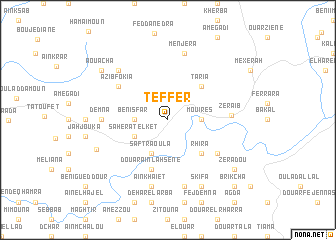
Teffer (Larache, Morocco)Teffer is a town in the Larache region of Morocco. An overview map of the region around Teffer is displayed below.
regional and 3d topo map of Teffer, Morocco ::
Teffer airports ::
The nearest airport is TTU - Tetouan Saniat Rmel, located 69.1 km north east of Teffer.
Other airports nearby include TNG - Tanger Ibn Batouta (80.7 km north), NNA - Kentira Kenitra (119.0 km south west), GIB - Gibraltar (127.0 km north), MEK - Meknes Bassatine (128.6 km south), Nearby towns ::
Beni Sfar (3.0km west) //
Mouîres (3.0km east) //
Saherat el Ket (3.6km south west) //
Saf Traoula (4.0km south) //
Rhira (4.8km south east) //
Taria (4.8km north east) //
Douar Aïn Lahsene (5.8km south) //
Beni Mohammed (5.9km south east) //
Azib Fokia (5.9km north west) //
Zerâïb (5.8km east) //
Demna (6.1km west) //
Aïn Khaïet (7.6km south) //
Zaïdour (7.6km south) //
Menjera (7.6km north) //
Azib Seflia (7.2km north west) //
Skifa (8.0km south) //
Ez Zʼara (7.3km south west) //
Aouacha (8.2km north west) //
Zeradou (8.2km south east) //
Brikcha (9.6km south east) //
[all distances 'as the bird flies' and approximate]  Places with similar names to Teffer, Morocco ::
Disclaimer :: Information on this page comes without warranty of any kind |
||
|
Where is Teffer? Elevation and coordinates ::
Latitude (lat): 35°2'0"N Longitude (lon): 5°39'0"W
Elevation (approx.): 245m (map arrows pan, magnifying glasses zoom) |
||
|
Visiting Teffer? Hotel/Accommodation ::
Book a hotel in Teffer Travel Guide ::
Buy a travel guide for Morocco rental cars ::
car rental offers GPS waypoint ::
download a GPX waypoint (PoI) of Teffer for your GPS receiver
|
||