|
search place name
|
||
Alajag (Leyte, Philippines)Alajag is a town in the Leyte region of Philippines. An overview map of the region around Alajag is displayed below.
regional and 3d topo map of Alajag, Philippines ::

Alajag airports ::
The nearest airport is TAC - Tacloban Daniel Z Romualdez, located 23.6 km east of Alajag.
Other airports nearby include NOP - Masbate Mactan Cebu Intl (133.3 km south west), BCD - Bacolod (214.8 km west), DGT - Dumaguete (263.5 km south west), Nearby towns ::
Santiago (1.9km north) //
Ylandoguia (1.8km west) //
Buri (1.8km west) //
San Isidro (1.9km east) //
Gapas (2.0km south east) //
Bolod (2.6km south east) //
San Roque (2.6km south west) //
Burabud (2.6km north east) //
Buenavista (2.6km north east) //
Galotan (2.6km north west) //
Pange (2.8km south) //
San Vicente (2.9km north) //
Kabungaan (2.9km south east) //
Buenavista (3.2km north west) //
Cavite (3.6km north) //
Santa Cruz (3.6km south east) //
Iphag (3.7km south) //
Bito (3.7km north) //
San Agustin (3.6km west) //
Ilawod (3.6km west) //
Burabud (3.6km west) //
Parasan (3.6km west) //
Bi-as (3.6km west) //
Mainit (3.8km north east) //
Jaro (3.8km west) //
Binongloan (3.9km north) //
Hibunawon (3.9km south) //
Macanip (4.0km south west) //
Bugho (4.1km north east) //
[all distances 'as the bird flies' and approximate] 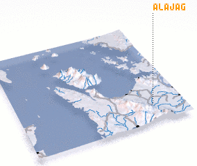 Places with similar names to Alajag, Philippines ::
Disclaimer :: Information on this page comes without warranty of any kind |
||
|
Where is Alajag? Elevation and coordinates ::
Latitude (lat): 11°11'0"N Longitude (lon): 124°49'0"E
Elevation (approx.): 73m (map arrows pan, magnifying glasses zoom) |
||
|
Visiting Alajag? Hotel/Accommodation ::
Book a hotel in Alajag Travel Guide ::
Buy a travel guide for Philippines rental cars ::
car rental offers GPS waypoint ::
download a GPX waypoint (PoI) of Alajag for your GPS receiver
|
||