|
search place name
|
||
Andres Bonifacio (Philippines)Andres Bonifacio is a town in Philippines. An overview map of the region around Andres Bonifacio is displayed below.
regional and 3d topo map of Andres Bonifacio, Philippines ::

Andres Bonifacio airports ::
The nearest airport is BCD - Bacolod, located 46.3 km south west of Andres Bonifacio.
Other airports nearby include ILO - Iloilo (80.3 km west), NOP - Masbate Mactan Cebu Intl (104.5 km south east), KLO - Kalibo (127.3 km north west), SJI - San Jose Antique (144.9 km west), Nearby towns ::
Tinampaan (2.5km north) //
Toril (2.6km north east) //
Mabini (3.5km east) //
Trozo (3.9km north east) //
Catapud (5.6km north) //
Bayabas Hacienda (5.9km north) //
Carmen Hacienda (5.9km north) //
Baquias (5.9km north) //
Luna (5.9km north) //
Burgos (6.9km north west) //
Daga (7.0km north east) //
Putayputay (7.3km south west) //
Kaduhaan (7.4km north west) //
Cadiz (7.9km north east) //
Cabahug (8.2km north east) //
Sicaba (8.8km north) //
Pinanamaan (8.8km west) //
Dalayapan (9.3km west) //
Banquerohan (9.6km north east) //
Chambery (9.6km north west) //
Sicaba (9.8km south west) //
[all distances 'as the bird flies' and approximate] 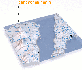 Places with similar names to Andres Bonifacio, Philippines ::
// Andres Bonifacio (PH)
// Andres Bonifacio (PH)
// Andres Bonifacio (PH)
// Andres Bonifacio (PH)
// Andres Bonifacio (PH)
Disclaimer :: Information on this page comes without warranty of any kind |
||
|
Where is Andres Bonifacio? Elevation and coordinates ::
Latitude (lat): 10°55'0"N Longitude (lon): 123°15'0"E
Elevation (approx.): 34m (map arrows pan, magnifying glasses zoom) |
||
|
Visiting Andres Bonifacio? Hotel/Accommodation ::
Book a hotel in Andres Bonifacio Travel Guide ::
Buy a travel guide for Philippines rental cars ::
car rental offers GPS waypoint ::
download a GPX waypoint (PoI) of Andres Bonifacio for your GPS receiver
|
||