|
search place name
|
||
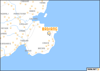
Badiang (Bohol, Philippines)Badiang is a town in the Bohol region of Philippines. An overview map of the region around Badiang is displayed below.
regional and 3d topo map of Badiang, Philippines ::
Badiang airports ::
The nearest airport is NOP - Masbate Mactan Cebu Intl, located 87.4 km north west of Badiang.
Other airports nearby include DGT - Dumaguete (149.6 km west), CGY - Ladag Cagayan De Oro (152.2 km south), TAC - Tacloban Daniel Z Romualdez (166.2 km north), BCD - Bacolod (204.2 km north west), Nearby towns ::
Calayugan (1.0km north) //
Linawan (1.5km south east) //
Tayud (2.0km south) //
Talisay (2.4km south east) //
Pangpang (2.9km north west) //
Anoling (3.7km south) //
Suba (3.7km south) //
Casica (4.2km south) //
Anda (5.1km south) //
Cambuyo (5.2km north west) //
Panas (6.3km north west) //
Bacong (6.7km south west) //
Anajao (7.3km north west) //
Canoling (7.7km west) //
Cogtong (7.8km north west) //
Candabong (8.2km south west) //
Guio-ang (8.2km west) //
Cawayanan (9.8km north west) //
Mabini (10.3km north west) //
Basdio (10.4km south west) //
Tankigan (12.0km north west) //
[all distances 'as the bird flies' and approximate] 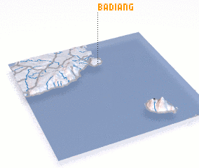 Places with similar names to Badiang, Philippines ::
Disclaimer :: Information on this page comes without warranty of any kind |
||
|
Where is Badiang? Elevation and coordinates ::
Latitude (lat): 9°47'29"N Longitude (lon): 124°34'59"E
Elevation (approx.): 29m (map arrows pan, magnifying glasses zoom) |
||
|
Visiting Badiang? Hotel/Accommodation ::
Book a hotel in Badiang Travel Guide ::
Buy a travel guide for Philippines rental cars ::
car rental offers GPS waypoint ::
download a GPX waypoint (PoI) of Badiang for your GPS receiver
|
||