|
search place name
|
||
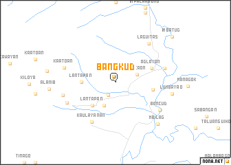
Bangkud (Bukidnon, Philippines)Bangkud is a town in the Bukidnon region of Philippines. An overview map of the region around Bangkud is displayed below.
regional and 3d topo map of Bangkud, Philippines ::
Bangkud airports ::
The nearest airport is CGY - Ladag Cagayan De Oro, located 67.0 km north west of Bangkud.
Other airports nearby include CEB - Cebu Cotabato (136.1 km south west), LGP - Legazpi Pagadian (180.6 km west), DGT - Dumaguete (243.3 km north west), Nearby towns ::
Bantuanon (2.4km south west) //
Bugcaon (3.7km east) //
Mailag (4.1km south west) //
Lantapan (5.2km south west) //
Lantapan (5.5km west) //
Cabangahan (6.1km east) //
Aglayan (6.2km east) //
Kaulayanan (7.5km south west) //
Linabo (8.2km east) //
Laguitas (8.3km north east) //
Balila (8.4km south west) //
Bancud (8.4km south east) //
Kaatoan (8.5km west) //
Baclayon (8.7km west) //
Mailag (9.5km south east) //
[all distances 'as the bird flies' and approximate]  Places with similar names to Bangkud, Philippines ::
// Banogcot (PH)
// Ban Ko Ket (TH)
// Ban Ko Koet (TH)
// Bangakété (CF)
// Banga-Kete (CD)
// Banga-Kota (CD)
// Bangketa (ID)
// Bengkudu (ID)
// Bonkoguadou (GN)
// Ban Kèo Kout (LA)
Disclaimer :: Information on this page comes without warranty of any kind |
||
|
Where is Bangkud? Elevation and coordinates ::
Latitude (lat): 8°2'0"N Longitude (lon): 125°5'0"E
Elevation (approx.): 520m (map arrows pan, magnifying glasses zoom) |
||
|
Visiting Bangkud? Hotel/Accommodation ::
Book a hotel in Bangkud Travel Guide ::
Buy a travel guide for Philippines rental cars ::
car rental offers GPS waypoint ::
download a GPX waypoint (PoI) of Bangkud for your GPS receiver
|
||