|
search place name
|
||
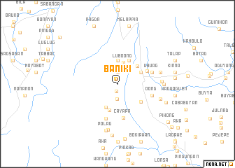
Baniki (Ifugao, Philippines)Baniki is a town in the Ifugao region of Philippines. An overview map of the region around Baniki is displayed below.
regional and 3d topo map of Baniki, Philippines ::
Baniki airports ::
The nearest airport is BAG - Baguio, located 71.9 km south west of Baniki.
Nearby towns ::
Abuanan (1.2km south) //
Taual (1.9km north) //
Hapao (2.3km south) //
Lubo-ong (3.5km north) //
Bocos (3.7km north) //
Gohang (4.1km north east) //
Uja (4.0km north east) //
Kutapic (4.1km south west) //
Kisang (4.2km north east) //
Ibayong (4.3km south) //
Halong (4.6km south east) //
Banawe (5.0km north east) //
Cayapa (5.5km south) //
Oong (5.6km east) //
Amganad (5.6km east) //
Banao (5.6km east) //
Bockiaman (5.6km east) //
Dango (5.8km south) //
Gode (5.8km south) //
Humalaphap (5.6km east) //
Latagin (5.8km south) //
Polod (5.8km south) //
Ubuag (5.6km east) //
Poitan (6.8km east) //
Bayninan (6.9km east) //
Cababuyan (7.0km east) //
Pakitan (7.1km east) //
Hungduan (7.5km south) //
Nompalling (7.6km south) //
[all distances 'as the bird flies' and approximate]  Places with similar names to Baniki, Philippines ::
Disclaimer :: Information on this page comes without warranty of any kind |
||
|
Where is Baniki? Elevation and coordinates ::
Latitude (lat): 16°54'0"N Longitude (lon): 121°1'0"E
Elevation (approx.): 913m (map arrows pan, magnifying glasses zoom) |
||
|
Visiting Baniki? Hotel/Accommodation ::
Book a hotel in Baniki Travel Guide ::
Buy a travel guide for Philippines rental cars ::
car rental offers GPS waypoint ::
download a GPX waypoint (PoI) of Baniki for your GPS receiver
|
||