|
search place name
|
||
Cabaritan (Ilocos Sur, Philippines)Cabaritan is a town in the Ilocos Sur region of Philippines. An overview map of the region around Cabaritan is displayed below.
regional and 3d topo map of Cabaritan, Philippines ::

Cabaritan airports ::
The nearest airport is BAG - Baguio, located 143.0 km south of Cabaritan.
Nearby towns ::
Flora (0.0km north) //
Padu Chico (0.7km north) //
Lagatit (1.9km south) //
Pussuac (1.9km south) //
Binalayangan (1.9km south) //
Santa Cruz (1.9km north) //
Paguraper (1.8km west) //
Panay (1.8km west) //
Santo Domingo (2.0km south east) //
Pangpangdan (2.1km north) //
Quintarong (2.6km south east) //
Payad (2.6km south east) //
Cabigbigaan (2.6km south east) //
Padu Grande (2.6km south east) //
Longboy (2.6km south west) //
Naglaoaan (2.6km south west) //
Casili (2.6km north west) //
San Ildefonso (3.1km south) //
Calay-ab (3.5km west) //
Lussoc (3.5km east) //
Borobor (3.5km east) //
Panay (3.7km north) //
Sived (3.5km west) //
Malingeb (4.1km south east) //
Cabusligan (4.1km south east) //
Santo Tomas (4.0km south east) //
Nambaran (4.0km south east) //
Bungro (4.0km south east) //
Paras (4.0km north east) //
[all distances 'as the bird flies' and approximate] 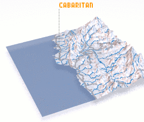 Places with similar names to Cabaritan, Philippines ::
Disclaimer :: Information on this page comes without warranty of any kind |
||
|
Where is Cabaritan? Elevation and coordinates ::
Latitude (lat): 17°39'0"N Longitude (lon): 120°24'0"E
Elevation (approx.): 8m (map arrows pan, magnifying glasses zoom) |
||
|
Visiting Cabaritan? Hotel/Accommodation ::
Book a hotel in Cabaritan Travel Guide ::
Buy a travel guide for Philippines rental cars ::
car rental offers GPS waypoint ::
download a GPX waypoint (PoI) of Cabaritan for your GPS receiver
|
||